High Lake beckons from the clouds
Published 5:00 pm Tuesday, August 5, 2003
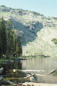
- From the south shore of High Lake in the Strawberry Mountain Wilderness, greenery still clings to the cliffs in early July. The wilderness encompasses 68,700 acres and resides in a pine, fir and larch forest south of Prairie City. High Lake Trail passes through forest and meadowlands and provides access to a backpacking loop. DAVID CARKHUFF photo.
LOGAN VALLEY – Catch your breath before you embark on the plunging downhill hike into High Lake.
From the Forest Road 1640 trailhead, this 1.3-mile drop features breath-taking views and high-elevation vistas. On the southeastern fringe of the Strawberry Mountain Wilderness, the High Lake trail ranges from 7,450 to 8,000 feet in elevation.
“A lot of people like to go to High Lake to go fishing,” said Carole Holly, recreation program manager for the Malheur National Forest.
So don’t be surprised to meet hikers with fishing poles on the trail. The 5-acre lake at the headwaters of Big Creek, splendidly flanked by rocky outcroppings, features excellent brook trout fishing. Bug repellent is highly recommended on both the trail and at the lake. Holly reminded hikers to keep their eyes open for snags. A 2002 fire at High Lake weakened many trees, and wind or lightning could cause snags to fall on the trail. Weather conditions can be unpredictable, so hikers should pack accordingly.
Visitors to Strawberry Lake from the north end of the wilderness, via County Road 60 and Forest Road 6001 south of Prairie City, may complete the loop to High Lake. On the east end of the loop is Slide Lake; the west end curls up to Strawberry Mountain and approaches Indian Spring Butte before connecting with the High Lake trailhead.
Bears inhabit the wilderness, so campers should store food carefully, and, as always, hikers should practice a leave-no-trace ethic. For more information, call Holly at (541) 575-3000.
HOW TO GET THERE:
From Prairie City, go south on County Road 62 to Forest Road 14. At Summit Prairie, take Forest Road 16 to Logan Valley. At Forest Road 1640 (the road to Lake Creek Youth Camp), go north to the High Lake Rim. From Seneca, turn left onto County Road 65 and access Forest Road 16. Distances to the trailhead: 19 miles from Summit Prairie; 10 miles from Lake Creek Youth Camp; 12 miles from the turnoff on Forest Road 924 (the road to the youth camp).