SNOW SPORTS
Published 5:00 pm Thursday, April 24, 2008
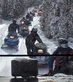
- For more information on these and other snowmobile trails and skiing areas, pick up a snowmobile map at the Grant County Chamber of Commerce in John Day. <i>File Photo</i>
Snowmobilers and skiers are in good hands when it comes to finding trails to travel in Grant County. The Malheur National Forest has 502.5 miles of designated snowmobile routes and 6.5 miles of ski trails with another 24.4 miles soon to be designated.
Trending
Trails are marked well throughout the recreational areas with trailhead markers colored in a reflectorized brown and creme with orange diamonds and/or user symbols used in conjunction to denote appropriate users for each trail.
Road crossing signs, road closures, trail identification, trail blazer (reassurance markers for snowmobile trails), guide poles, direction symbol (arrow signs), intersection (location number), informational, regulatory, warning and wilderness signs are placed on each trail route.
The Grant County Snowballers have completed a new shelter at the Huddleston Park which has a large block building with an open pit fire area, along with parking for easy access to many trails. For the club’s schedule of activities go the the Grant County Chamber of Commerce. Website: www.grantcounty.cc
Trending
The following are the districts which have snowmobile and cross-country ski trails:
Prairie City
The Prairie City District has 242.5 miles in trails including these larger ones:
Malheur Trail, S-390, from Austin Highway to Lake Creek Camp, 78.5 miles.
High Lake Overlook, S-391, Road 16 to Roads End, 11 miles.
Frazier Loop, S-392, Road 1648 to Road 16, 33 miles.
Clear Creek, S-393, Highway 26 to 2652, 14 miles.
Dixie/Reynolds Creek, S-394, Highway 26 to 2652, 15 miles.
Fopian, S-390B, Road 1370 to Road 13, 10 miles.
Lower Summit, S-390D, Road 16 to Road 14, 10 miles.
Malheur/Logan, S-396, Road 1649 to Road 1643, 10 miles.
Wickiup, S-397, Road 16 to Road 1647, 11 miles.
Blue Mountain
The Blue Mountain District has 156 miles of snowmobile trails including:
Malheur Trail, S-200, Lake Creek Camp to Highway 395 Starr Ridge, 36 miles.
Ingle Rock, S-210, Highway 395 to 21, 15 miles.
Horse Mountain Loop, S-201, Road 4955 to Road 4955, 30 miles.
This district also has a 6.5 mile cross-country ski trail – the Snowshoe Ski Trail – located at Trail #220.
Vincent, S-257, County Road 20 to Vinegar Hill, 15 miles.
Crawford Creek, S-258, Austin Junction to Highway 7, 12 miles.
Summit Creek, S-259, Crawford Creek to East Forest Service Boundary, 10 miles.
Emigrant
The Emigrant District has 104 miles in snowmobile trails including:
King Mountain, S-308, Highway 395 Idlewild to Lake Creek Camp, 76 miles.
Idlewild West Loop, S-309, Highway 395 to Highway 395, 18 miles.
Marketplace


-
eEdition

-

-
