TOWN HISTORY
Published 5:00 pm Wednesday, April 30, 2008
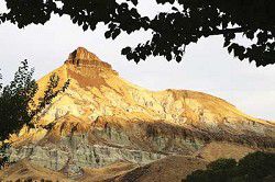
- Sheep Rock is one of the many breathtaking views to take in on your journey from Dayville to Kimberly. <i>National Park Service</i>
KimberlyLocated where the North Fork meets the main stem of the John Day River at the intersection of Highways 19 & 402 lies the scenic ranching community of Kimberly, Oregon. In Northern Grant County, there is likely more wild game animals, horses and livestock in this lush valley than the handful of residents in this sleepy little neighborhood town.
Trending
Kimberly is known to most who visit for its one – stop shopping, great weather and multitude of outdoor opportunities. The Kimberly Center at 1st and Main on Hwy. 19 offers groceries, gas and a post office within and serves as the only building in the “city limits.” Numerous other businesses with people who work from their homes reside in this scenic vista and share nature at its best.
This is an area where numerous tracts of privately owned properties meet public lands and local ranches sport fee hunting as extra income, and landowners appreciate those who respect private property signs. Big game viewing is not uncommon on these parcels along the river when one travels through. A multitude of opportunities abound for camping and hunting on public lands with avid hunters coming back yearly to enjoy the North Side and Heppner Units for big game adventures. The hunting season draws nature lovers and sportsmen alike who appreciate the people, friendly atmosphere and the sparsely populated town called Kimberly. This is still an undiscovered terrain where century year old ranch families continue to make their living off this land before time.
According to locals, the town was established in the late 1940s by its namesake, Orin Kimberly, whose family homesteaded the area and planted the beginning of what is now known as the Thomas Orchards. Family owned and operated for the past 5 decades, the orchard supplies numerous varieties of fresh fruit that are sold to the public at their fruit stand during the summer months. Folks travel for miles around to pick their own produce or buy by the pound, bushel or box. Fresh fruit is shipped to the northwest from Kimberly, which is also known for its good climate, great gardens and extended growing season.
Trending
The orchards seasonally flowering fruit trees provide a colorful backdrop to those traveling to Kimberly through the outskirts of Grant County on Hwy 19 north of Dayville. This route also takes many tourists on a picturesque drive filled with blue skies, rushing rivers and green fields full of hay, wildlife and livestock.
Bicyclists, motorcyclists, hikers, car clubs and bus tours make this part of their loop trip in the summer months. More and more people are finding their way over to this remote haven for solitude and relaxation. This is prime country for raising livestock, horses and families.
The North Fork of the John Day River features excellent fishing for steelhead and bass. Visitors and locals alike enjoy rafting, tubing, swimming, sunbathing and picnicking from Lone Pine or Big Bend state park on Hwy. 402. The rock hounding, hiking, wildlife, fish and bird population make this an area of great interest to enthusiasts who are also curious about this prehistoric setting, the beautiful photography it offers and the unique holdings that are open to the public all within close proximity to the landmark known as the John Day Fossil Beds National Monument.
Mt. VernonMt. Vernon is located at the crossroads of highways 26 and 395; in the heart of Grant County.
Mt. Vernon is a community with the spirit of a thoroughbred and was named after a locally famous racehorse.
Mt. Vernon was a chestnut-sorrel trotting horse and was so treasured that a special stone fort was built in 1879 to protect him from being stolen by the Indians. The stone fort is still standing between Mt. Vernon and John Day and the date 1879 is carved above the window.
The City of Mt. Vernon was formally incorporated in 1948 and the principal industry was agriculture, stock raising and lumbering. While the local sawmills are now gone, the area is surrounded by pastoral fields where hay and livestock are raised and the town is surrounded by the Malheur National Forest and the view of the mountains is spectacular.
The city maintains a fairly stable population of 595.
With a rich rural history, the community is turning tradition toward the future. While there have been some rough economic times, Mt. Vernon has its eye toward the future with the philosophy that positive actions bring positive results.
Mt. Vernon is very fortunate to have the John Day River flowing through it. The community is working on building a riverfront park and they are completing a greenbelt trail from the river park to Clyde Holliday State Park, 1.5 miles east. The city has acquired acreage along the river and through many generous offerings of easements and other lands, this project is taking shape.
Mt. Vernon can be best described by its mission statement: “To cherish our heritage, explore the possibilities of our future, feel pride in the enthusiasm of our youth, appreciate the wisdom of our aged and to provide opportunities for all.”
MonumentSettled into a quiet valley on the banks of the North Fork of the John Day River is the small community of Monument.
The area surrounding what is now Monument was first settled on in 1852 and was incorporated in 1947.
The town was named for a peculiar rock or mountain nearby that resembles a pulpit or rostrum. This peak is called Monument Mountain.
Lots of travelers also stop and enjoy the well-shaded and manicured city park as well as the Cavender Boat Launch
and picnic area. This is where floaters can shuttle in or out with their fishing boats, rafts or canoes to enjoy the river activities.
All-in-all, the Monument Valley offers spectacular vistas of the surrounding sage and juniper covered basalt rimrocks. Whether you are interested in fishing, hunting, hiking, white water-rafting or just seeking a quiet respite from the hectic pace of life, Monument has it, along with the warm hospitality of a small friendly community.
Canyon CityCanyon City was born in 1862 as a mining camp that grew along Canyon Creek after gold was discovered on Whiskey Flat, located a short distance north of Canyon Creek.
For some time there was an influx of miners, perhaps as many as 10,000 lived along the single Whiskey Gulch Street. It has been estimated that about $20 million was mined from the Canyon Creek diggings over 10 years. The mining declined in the 1870s but the town did not die.
There were conflicts between Union and Confederate sympathizers. When California miners raised the Confederate flag on Rebel Hill on July 4, 1863, the Union-sympathizing Oregon miners stormed the hill and tore down the flag.
Incorporated and organized in 1891, the town is rich in history. Two historic murals and a beautiful sign next to the City Hall depict Canyon City’s exciting historic significance.
The historic community is the county seat of Grant County, and derives its name from the fact that it is situated in a canyon about two miles south of the John Day River.
Today, Canyon City is home to 670 residents who enjoy scenic beauty, good water, and strong community leadership, which make it a desirable place to live.
Canyon City’s quaint downtown area attracts visitors of all ages. The City Park in the heart of town is a favorite picnic spot as well as play area of the local young people. Residents of the entire county enjoy the annual Music in the Park series, performed during the summer months.
John DayJohn Day was founded around the same time as Canyon City in 1862. Located at the mouth of Canyon Creek, mining was the sole support of the community in the beginning. Then agriculture slowly took hold.
The town was officially called John Day in 1865 after the river that flows through the valley. It was known as “Lower Town” by the miners who lived up and down Canyon Creek. By the end of 1864, two saloons were doing business and in 1865, another pioneer built a blacksmith shop. A flour mill also was built at the mouth of Canyon Creek.
In those days many robberies occurred in the community. Weapons were carried by everyone, which was typical of mining communities. In the late 1860s, the population began to scatter as the mining gave out. During the 1870s, the Chinese were about the only miners left in the area who considered Canyon Creek worth working.
After the destruction of Chinatown in 1885 in Canyon City and the subsequent refusal of the residents there to let the Chinese rebuild, the Chinese moved to John Day. At one time, a Chinatown of 4,000 to 6,000 inhabitants was thriving.
In 1888, John Day was incorporated and the first mayor and city council members were appointed.
Today, John Day features the county’s only public swimming pool, skate park and the Seventh Street Complex, a series of baseball, softball, soccer fields and a walking path operated by John Day/Canyon City Parks & Recreation District, 541-575-0110.
SenecaThe town was named for Judge Seneca Smith of Portland and was the hub of the county’s railroad logging industry until the sawmill closed.
Today, it is home to 220 residents and the Seneca School, which instructs kindergarten through eighth-graders and is part of the Grant School District 3 headquartered in John Day.
Seneca is the gateway to Logan Valley and is capitalizing on its proximity to prime hunting territories and winter recreation spots.
The city, which sits at 4,666 feet elevation, can at times be the coldest town in Oregon. It has been known to dip to 50 degrees below zero.
Seneca also boasts Grant County’s other golf course besides the ones located in John Day and south of Dayville. The city-owned Bear Valley Golf Course offers nine holes that will delight most duffers seeking a challenge and some beautiful scenery.
In May, Seneca hosts its annual Oyster Feed, which is a fund-raiser for the golf course.
IzeeThe community of Izee is located near the South Fork of the John Day River.
Stephen Meek believed he could lead a wagon train more directly across the state, cutting off the long miles from Boise to the Columbia River, by going through this area. In 1845, he found a large number of families willing to follow him. Among the families included were James and Eveline Cooley Officer. A son of this couple returned to Grant County 40 years later in 1884.
In 1882, the Keerins brothers – Matt, Owen, Joseph and Dave – came into Izee with a band of sheep. They had come from Ireland to San Francisco and then to Grant County.
For a short time there were two schoolhouses in Izee. One near Rickmans and the other at the present location. At the peak of the homestead days, there were as many as 50 families in this area. The 1929 depression saw many families leave and the present ranches began to jell – buying out the smaller homesteads.
In 1946, a lumber mill was built about five miles below the Keerins Ranch by the Ralph Smith Lumber Co. The mill sawed 40,000 feet per day and increased this number to 85,000. The mill was sold to Ellingson Lumber Co. and in 1969 was dismantled.
With the exit of the mill, Izee was once again back to cattle only, with about twice as many ranches as in 1870.
FoxFox was named after Fox Creek, an important tributary of the North Fork of the John Day River. The name was applied to the stream in the pioneer days because of an incident that occurred on a hunting or prospecting trip involving a fox.
AustinThis community was named for Mr. and Mrs. Monot Austin, early settlers, who operated a small store and hotel not far from the current site of the town.
BatesBates was located about two miles from Austin Junction toward Baker City.
The town was named for Paul C. Bates, an insurance man from Portland. Bates was instrumental in negotiating the purchase of timberlands by the Oregon Lumber Co. Bates was born in Massachusetts in 1864 and came to Portland in 1896. He died in Portland Feb. 7, 1943.
DaleA stage stop along the route to Pendleton north of the way from John Day to Pendleton, Dale is a long time U.S. Forest Service community.
GraniteCarved out of the untamed wilderness, the boom gold rush town of Granite was born.
The year was 1862, Independence Day; a group of men commanded by A.G. Tabor and A.J. Dickinson had made an
arduous journey along the south side of the John Day River. After resting from their long trek from The Dalles in the worst winter weather, they began building a new town. This town, south of present day Granite, was first designated Independence, Ore. because gold was discovered there on July 4, 1862.
In 1874, their request for a post office was denied because another town was registered under the same name in Oregon. Quickly the town reapplied under the new name of Granite. In 1900, Granite was moved to its present location, closer to the quartz-mining boom.
Today, amidst the ghosts of the past, a new town of Granite has emerged with a gas station, RV park, lodge, restaurant and a general store. Granite is now the stepping-off point into the untamed wilderness with abundant fishing, hunting, camping, snowmobiling and true to its history, you may even find some of Granite’s gold.
DayvilleEntering Grant County from the west, visitors to the John Day area wind through the narrow and tall red rock walls of the scenic Picture Gorge. Here, Highway 26 is but two lanes as the road hugs the banks of the John Day River. The river runs high with rapids in the winter and mild with small swimming holes in the summer. Once through the gorge, travelers emerge into the beautiful John Day Valley. Grazing cows are abundant and old barns and farmhouses dot the countryside. The valley is broad and flanked by high plateaus.
The small town of Dayville (population 160) is four miles east of the Picture Gorge. The historic western-front buildings transport visitors back in time. Dayville was first a stage stop on a military road in the late 1800’s and many of the old buildings remain. The Dayville Mercantile is now over one hundred years old and is still the main grocery and gift source for both tourists and local residents.
In the center of town is the Dayville Community Hall. A beautifully built, large, old wood structure, the hall is still used for the annual Fourth of July dance, plays by the South Fork Players, talent shows, and a variety of community events. Encased on an old balcony, the hall still houses an old propane-powered movie projector from the 1930s.
The Dayville Park, located at the east end of town, with frontage along the South Fork of the John Day River, has a public restroom, picnic tables, playground equipment, and lots of grass. The park is adjacent to the City Hall and library and area information is available there.
The area around Dayville is considered to be a hunting and wildlife paradise. The Northside, Murderers Creek and Ochoco hunting units intersect at Dayville making it a popular stop for deer and elk hunters, and also upland game bird hunters. The high desert scenery is popular with photographers, bird watchers and hikers.
Two miles out of Dayville, on the South Fork Road, is the South Fork Golf Course. The six-hole walking course
is open to the public and is home to the annual Cow Pasture Golf Tournament that is held in conjunction with Dayville’s Fourth of July celebration.
Long CreekFrom a scenic point of view, the town of Long Creek in the northern part of Grant County is delightfully situated. The town is located at the head of a valley, several miles in extent.
Long Creek is one of the older and larger of the outlying towns in Grant County.
Early history of Grant County indicates that the first ranchers settled in the Long Creek area in the early 1870s. Two were Nicholas Noble and John Paul.
Long Creek received its name when its post office was established in 1883. The first postmaster, J.M. Shields, gave Long Creek its name because it was thought at the time to be the longest creek in the state.
Because of the Indian wars of 1878, a fort was built east of Long Creek. The entire population of 100 men, women and children gathered there eight days after its construction to defend themselves should the Indians attack. When the Indians passed the fort on their way to Umatilla County, they went on by, thinking they were outnumbered.
Today, Long Creek welcomes visitors and friends to enjoy hunting and camping.
Campgrounds in the mountains are spacious and easily accessed from early spring to late fall. The area attracts bikers, hikers, fishermen, and folks who appreciate the quiet of the sparsely populated area.
The Social Security Pond west of Long Creek is a great spot for small tots, parents and oldsters to enjoy a fishing experience. The pond is stocked each spring with nice trout, but all year one can enjoy the goldfish or catch some for home aquariums.
Prairie CityPrairie City is one of the few remaining small towns in the USA where clean air, safe neighborhoods, and friendly people welcome visitors. Prairie City loves to share their greatest treasure: the awe-inspiring beauty that surrounds them.
Year-round outdoor activities are available. Hunters are welcome to visit and test their skills in the mountains during hunting season. In the winter, the sun glistens on the snow of the Strawberry Range, inviting exploration by cross-country skiers and snowshoers. Snowmobilers can enjoy many miles of groomed trails.
The Depot Museum, devoted to local history and housed in the former Prairie City railroad station, opens its doors on May 15. Camp Logan Days, a living history event, gives visitors a chance to visit the year 1867 in a military camp and the mining town of Dixie; this year’s time travel will take place on May 19 and 20.
June marks the opening of hiking season at the lower elevations. Mountain meadows are full of wildflowers and birdsong, and spring moves upward toward the mountaintop with each sunny day.
Mushroom picking is fun for the whole family and adds a gourmet touch to dinner. Bicyclists can ride an 80-mile loop around Strawberry Mountain. Pristine lakes, the free-flowing and scenic John Day River, and many creeks offer excellent fishing, canoeing, and rowing opportunities. Hikers, from beginning day trippers to advanced backpackers on longer trips, can find many miles of uncrowded trails, including the unforgettable view from the top of Strawberry Mountain (9,032 feet). Artists with camera or canvas may choose to portray wildlife, landscapes, and historic buildings. Dreamers can even pan for gold!
Join Prairie City residents for the all-day Fourth of July celebration sponsored by the Greater Prairie City Community Association. Enjoy a parade at noon, followed by a picnic with barbecue and strawberry shortcake. Stay for a spectacular fireworks show provided by the City of Prairie City.
August 6, will find Prairie City bustling with the Arts and Antique Show in Depot Park, and the 12th annual Grant County Kruzers Show-n-Shine Car Show in the city park.
Live music, door prizes, demonstrations by artists, and country-style food complete the day.
Christmas on the Prairie will feature special promotions by local merchants, an art show, food, and a craft show, is held the Saturday before Thanksgiving.
Stay for a day or a month. Camp in the wilderness, or pamper yourself in a bed and breakfast. Shop in their unique downtown, feast on delicious food from our deli, bakery, and restaurants, and have a great vacation!
Go to www.prairiecityoregon.com to learn more about Prairie City.
Marketplace


-
eEdition

-

-
