Grant County: What a view!
Published 5:00 pm Monday, July 29, 2013
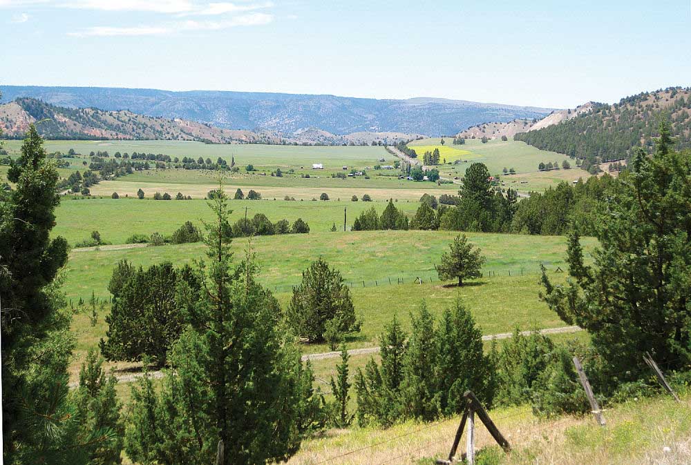
- <p>Hamilton ghost town area.</p>
It’s no secret that Grant County is a treasure trove of natural scenery.
And the variety can’t be beat either. From east to west, and north to south – sweeping valleys, majestic mountains, lush meadows and forests, ribboning creeks and rivers, and painted geological formations – there’s bound to be something to please or entice just about anyone.
Unfortunately, many winding mountain or canyon roads don’t always offer a space to pull off and enjoy the view. Or, by the time you realize there’s a good spot, it’s too late.
Here are a few locations along some main roadways in Grant County where you can safely pull off, take a breath – and a photo of a breathtaking view. Some are suitable for nothing bigger than a car or pickup, but others can accommodate several vehicles including larger rigs.
Mascall Formation Overlook
• Location: About 4-1/2 miles west of Dayville, on the south side of Highway 26. Turn at the “Overlook” sign, also called Antone Highway Road. Drive about a mile to the overlook. Accessible from both directions of travel.
• Plenty of parking for vehicles of all sizes, with designated areas for buses and motorhomes, and even spots for motorcycles. A loop drive leads back to the main road.
• The path from the parking lot to the viewpoint is wheelchair accessible.
• 360-degree views, of Picture Gorge, the Mascall formation area and western edge of the John Day River Valley. Several interpretive signs explain the history of the geologic formations, which are part of the John Day Fossil Beds National Monument.
• Restrooms available.
Covered Wagon
• Location: About 5 miles east of Prairie City, on the north (west) side of Highway 26. Turn at the “View Point” sign. Accessible from both directions of travel.
• Large parking area, with plenty of space for numerous vehicles of all sizes.
• Oversized Conastoga-style covered wagon, is a memorial of the Oregon Trail, and has displays with information on Prairie City and the John Day Valley area.
• View facing south and west, of Strawberry Mountain, the Strawberry Wilderness Range and the eastern edge of the John Day River Valley.
Logan Valley Interpretive Site
• Location: About 18 miles east of Seneca on the north side of Forest Road 16. Turn at the “Wildlife viewing” sign. Accessible from both directions of travel.
• Parking for several vehicles of all sizes. A loop drive leads back to the main road.
• Interpretive signs explain some of the wildlife viewing opportunities, in the flat, open range area, with views that include the south side of the Strawberry Wilderness Area.
• No services.
Long Creek overlook
• Location: Just under 2 miles south of Long Creek, at milepost 92.1B, on the east (north) side of Highway 395. Easy access for northbound travelers; southbound vehicles are advised to use caution turning left into the area.
• Undefined parking area, but large enough to accommodate a few vehicles of all sizes.
• View facing north of the town of Long Creek, nestled in the spacious open range and valley.
• No services, but Carter Park Rest Area is about one mile south on the highway.
Hamilton overlook
• Location: Between Long Creek and Monument, at about milepost 25 on the south side of Highway 402. Accessible only for eastbound travel.
• CAUTION: The roadway in this section is windy and uphill to the east. The small, short, pull-out area is suitable, width and length-wise, for only a couple of small vehicles.
• View to the west of the old community of Hamilton, now a ghost town. • No services.
Ritter overlook
• Location: About one mile south of the Ritter turnoff, on the west (north) side of Highway 395. Accessible only for southbound travel. There are a couple of nice spots, between mileposts 78 and 79.
• Undefined parking areas, but large enough to accommodate a few vehicles of all sizes.
• View facing north of the Ritter area and the Middle Fork of the John Day River.
• No services.
Keeney Fork view of Strawberry
• Location: About 5 miles north on Keeney Fork Road (County Road 18), which is 4 miles west of Prairie City off Highway 26. Accessible only for southbound travel. There are a couple of spots at about mileposts 4.9 and 5.2.
• CAUTION: The roadway here is windy and downhill to the south. The small, short, pull-out areas are suitable, width and length-wise, for only a couple of small vehicles.
• View facing south of Strawberry Mountain.
• No services.


-
eEdition

-

-

