Canyon Creek firefighters brace for difficult weather
Published 9:15 am Thursday, August 20, 2015
- Canyon Creek firefighters brace for difficult weather
Conditions appear ripe for more explosive growth on the Canyon Creek Complex wildfire south of John Day, as firefighters now dig in their heels to protect homes five miles away in the tiny mountain town of Seneca.
A red flag warning is in effect for Thursday afternoon through Friday evening on the fire lines, with wind gusts as high as 25-30 mph blowing out of the northwest.
Both days are expected to register a level 5 on the Haines Index, a meteorology tool used to gauge dry, unstable air in the atmosphere that could lead to erratic fire behavior. Level 5 indicates a medium potential for trouble.
Amanda Graning, incident meteorologist with the Canyon Creek Complex, said the forecast basically translates to extreme fire weather between relative low humidity and high winds.
“Anytime you have strong, gusty winds, you’ll be increasing the danger and potential for fire growth,” Graning said.
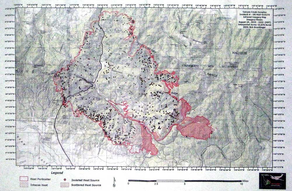
The Canyon Creek Complex grew Wednesday night to 53,876 acres and 10 percent contained, with fire lines holding on the northwest flank. Crews will send additional resources to the fire’s southern edge where they expect to see the most action, unless the winds suddenly change direction.
“You definitely still have a threat all around,” Graning said. “Terrains could be variable. Especially in the valleys, you could have local effects.”
The Grant County Sheriff’s Office says 36 homes have burned down and more than 50 structures damaged by the Canyon Creek Complex, which started Aug. 12. Another 700 structures are still threatened, with multiple evacuation orders along Canyon Creek and Highway 395.
It was a particularly fierce bout of wind on Friday, Aug. 14 that initially set the blaze on a wild path of destruction. That system came on the heels of a cold front tailing high, unstable winds throughout Eastern Oregon, Graning said.
The wind isn’t expected to blow as hard as it did a week ago, Graning said, but should remain gusty overnight and into Friday.
And, while the Haines Index is a factor in the daily forecast, she said that isn’t as much of a concern as the strong winds.
“The focus is more on the wind. We already know it’s dry,” Graning said.
Public information officer Damon Simmons said the plan is to prioritize first responders along the southern edges of the fire, where the wind is likely to spread flames and possibly chart a path down the canyon toward Seneca.
The city, population 200, is under a preliminary evacuation notice. Simmons said crews will continue to monitor homes and work to maintain the progress they’ve already made.
“The plan is just to hold the lines, and do so as safely as possible,” he said. “You have to really know where you are in the landscape.”
A fire information officer will be on hand at the Seneca post office from 1-5 p.m. to answer questions and provide information for residents.
Contact George Plaven at gplaven@eastoregonian.com or 541-9667-0825.