‘Squaw’ names replaced
Published 2:43 pm Tuesday, April 26, 2016
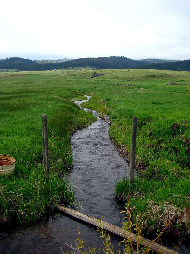
- Formerly Squaw Creek, now named Sharp Creek, crosses under County Road 60, as it flows from the Strawberry Mountain Wilderness northward toward Prairie City. The creek is one of 13 natural features in Grant County with “squaw” titles that have received new names, approved by the U.S. Board on Geographic Names.
Thirteen natural features in Grant County have been re-named, replacing “squaw” titles for new monikers proposed by the Grant County Court and the Confederated Tribes of the Umatilla Indian Reservation.
The U.S. Board on Geographic Names approved the new names April 14. The list includes eight creeks, one spring, three meadows and one rock.
Here are the new names, along with their locations, name origins and variant names, according to the U.S. Geological Survey’s Geographic Names Information System:
Location: 2.5 miles long, heads 15 miles north of Hamilton, flows southeast to the John Day River.
Origin: Umatilla origin, reportedly means “spirit.”
Location: 1.3 miles long, flows east then north into Škáypiya Creek, 13 miles north of Hamilton.
Origin: Umatilla origin, reportedly means “spirit.”
Location: Umatilla National Forest, 13 miles southwest of Granite and 14 miles northwest of Bates.
Origin: George W. Donaldson (1901-1992), a lifetime Grant County resident and avid outdoorsman. Donaldson logged with horses and loaded logs via narrow-gauge railroad. During the Depression, he worked with the Civilian Conservation Corps and later worked for the Forest Service with mining and surveying crews. He and his brother established the Donaldson Mine and built a cabin on the claim.
Variant name: Ha’áyatom Píswe Rock, from the language of the Umatilla Tribes, reportedly means “woman’s rock.”
Location: Umatilla National Forest, 2.7 miles long, heads 3.7 miles northwest of Granite, flows generally south-southwest to enter Granite Creek.
Origin: Umatilla origin, reportedly means “little.”
Location: Wallowa-Whitman National Forest, 4.8 miles northeast of Bates.
Origin: Myrtle boxwood plant found in the area.
Variant name: From the Umatilla Tribes language, reportedly means “to make stone tools out of a hard rock.”
Location: Wallowa-Whitman National Forest, 9.7 miles long, heads 16 miles northeast of Prairie City, 15 miles south of Granite.
Origin: Umatilla origin, reportedly means “scattered,” a reference to the streams flowing into that place.
Location: Wallowa-Whitman National Forest, 95 acres, 7 miles southeast of Bates, 19 miles southwest of Sumpter.
Origin: Umatilla origin, reported means “scattered,” a reference to the streams flowing into that place.
Location: Wallowa-Whitman National Forest, 35 acres, 6.9 miles southeast of Bates and 21 miles southwest of Sumpter.
Origin: Refers to the meadow’s location at the head of Frosty Gulch.
Variant name: Little Wíwaanaytt Meadow, from the Umatilla Tribes language, reportedly means “scattered.”
Location: Malheur National Forest, 5.7 miles long, heads just east of Squaw Butte, 15 miles south-southwest of Unity, flows south to the Little Malheur River.
Origin: Mona Cammann Browning (1903-1990), who, with her husband, both members of pioneer Oregon families, homesteaded on 600 acres on the stream in the 1930s.
Variant name: Waqíima Creek, from the Umatilla Tribes language, reportedly means “spirit.”
Location: Malheur National Forest, 9.7 acres, 23 miles south of Prairie City, 15 miles northeast of Silvies.
Origin: Dodecatheon meadia, a perennial wildflower with the common name “shooting star.”
Variant name: Sáykiptatpa Meadow, from the Umatilla Tribes language, reportedly means “at the medicine.”
Location: Malheur National Forest/Strawberry Mountain Wilderness, 10 miles long, flows north-northeast then north-northwest in Prairie City to the John Day River.
Origin: Phillip T. Sharp, who in 1872, homesteaded on 160 acres near the mouth of the stream.
Variant name: Nikéemex̣š Creek, from the Umatilla Tribes language, reportedly means “rough interiors.”
Location: 6.3 miles long, flows west-northwest then north-northeast along the west side of Sheep Ridge to enter Donaldson Creek, 25 miles northwest of John Day.
Origin: Honors Northern Paiute Chief We-You-We-Wa (“Wewa”).
Location: Bureau of Land Management land, heads at the confluence of Buckhorn and Indian creeks, flows east then east-southeast to the John Day River.
Origin: Associated with nearby Goose Rock.
Variant name: Ákakpa Creek, from the Umatilla Tribes language, reportedly means “at the goose.”


