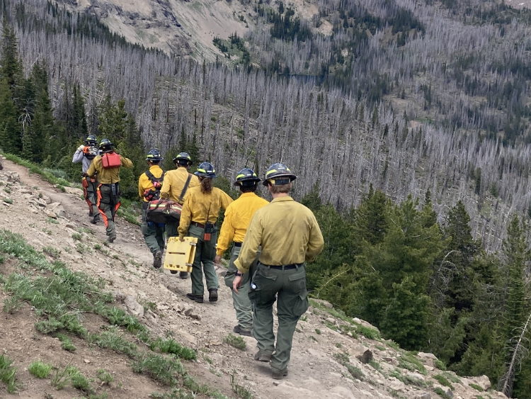
Black Butte Fire grows to 5,700 acres Thursday morning
Published 11:30 am Thursday, August 5, 2021
The Black Butte Fire 8 miles northeast of Antelope Lookout has grown to about 5,700 acres and has closed several recreation sites.
The fire 25 miles south of Unity, which started Aug. 3, is 0% contained, according to a Thursday morning update from High Desert Incident Command Team Type 3, which took over management of the fire Aug. 4.
Today, crews will continue to work to stop the spread of the fire north towards Flag Prairie and private lands, and south and southeast towards the forest boundary. Air resources will continue assisting and will work with the Type 3 team in the days to come.
An order has been placed for a Type 2 team but has not yet been filled. Ongoing fire activity in the Pacific Northwest is causing a limited amount of resources to be available.
Tomorrow, crews will continue to establish a foothold on the southern end of the fire to prevent spread to the south, utilizing existing roads on the east and west flank. This same strategy will be used to establish possible control lines to the north.
Closures: Temporary fire area closure in effect for public and fire staff safety in the following area: From National Forest System (NFS) road 14 at T. 18 S, R. 34 E, Section 24, North to the junction with NFS road 16 at T. 16 S, R. 34 E, Sec. 23. East on NFS road 16 to the forest boundary at T. 15 S, R. 36 E, Section 25. South along the forest boundary to T. 18 S, R 36 E, Sec. 24. West along southern forest boundary to NFS road 14 at T. 18 S, R. 34 E, Sec. 24. Border roads will remain open.
Recreation Sites within the closure boundary:
• North Fork Malheur River Trailheads both north and south
• North Fork Malheur Campground
• Crane Crossing Trailheads both east and west
Sites open to the west of the closure boundary are:
• Elk Creek Campground to the west of the boundary.
• Little Crane Campground
• Short Creek Guard Station
The public is reminded that the Malheur National Forest is under Phase C of Public Use Restrictions. For more information on Public Use Restrictions, call 541-575-3113.
Fire Information: Inciweb: https://inciweb.nwcg.gov/incident/7770/
Oregon Department of Forestry
No new fires were reported in the John Day Unit Wednesday. Extended attack on fires in the John Day Unit have been fully transitioned to mop-up. Today this work will continue as firefighters prepare for strong winds as thunderstorms pass through the area. Firefighting resources from these fires will be available to assist in initial attack of any new fire starts today.
Management of the Cottonwood Creek Fire transitioned to a Type 4 incident commander Wednesday. Crews on the fire continue to grid for smoldering fuel and extinguish hot spots as they work toward the interior of the fire from the perimeter. Two hand crews, five wildland engines and one water tender are assigned to the fire. The remaining mop-up work is expected to last several more days.
Resources on the Dissel Creek Fire, reported Tuesday evening burning 5 miles southeast of John Day, will continue mop-up work today. The approximately 1-acre fire is staffed with four engines and a squad. The fire is anticipated to be transitioned to patrol status at the end of shift today.
Fireline construction is nearly complete on the 150-acre Cole Canyon Fire. Yesterday helicopters and Single Engine Air Tankers were used to slow the spread of the fire, allowing hand crews to build fireline adjacent to the fire’s edge. This work, along with mop-up in other area’s of the fire have increased containment to 25%. Today four 20-person hand crews, two wildland engines, two water tenders and four skidgines will work to complete the line around the fire, strengthen the existing fireline and work to increase the cold black area between the fire and the fireline. Aircraft is available to assist firefighters as needed.
A red flag warning has been issued by the National Weather Service for the area for abundant lightning and gusty winds. This weather in combination with severely dry fuels poses a high risk of rapid fire spread.
A Regulated-Use Closure is in effect for the Central Oregon District to reduce human caused fires. The full proclamation and restrictions are available at https://gisapps.odf.oregon.gov/firerestrictions/PFR.html. Preventing human caused fires allows firefighters to focus suppression effort on fires started by lightning. These focused activities result in smaller fires with less damage to natural resources and communities and fewer impacts to air quality.
For additional information on ODF’s Central Oregon District, including contact information and unit offices, visit ODFcentraloregon.com.


-
eEdition

-

-

