Oregon’s snowpack gets a wintry boost
Published 5:00 pm Monday, March 4, 2024
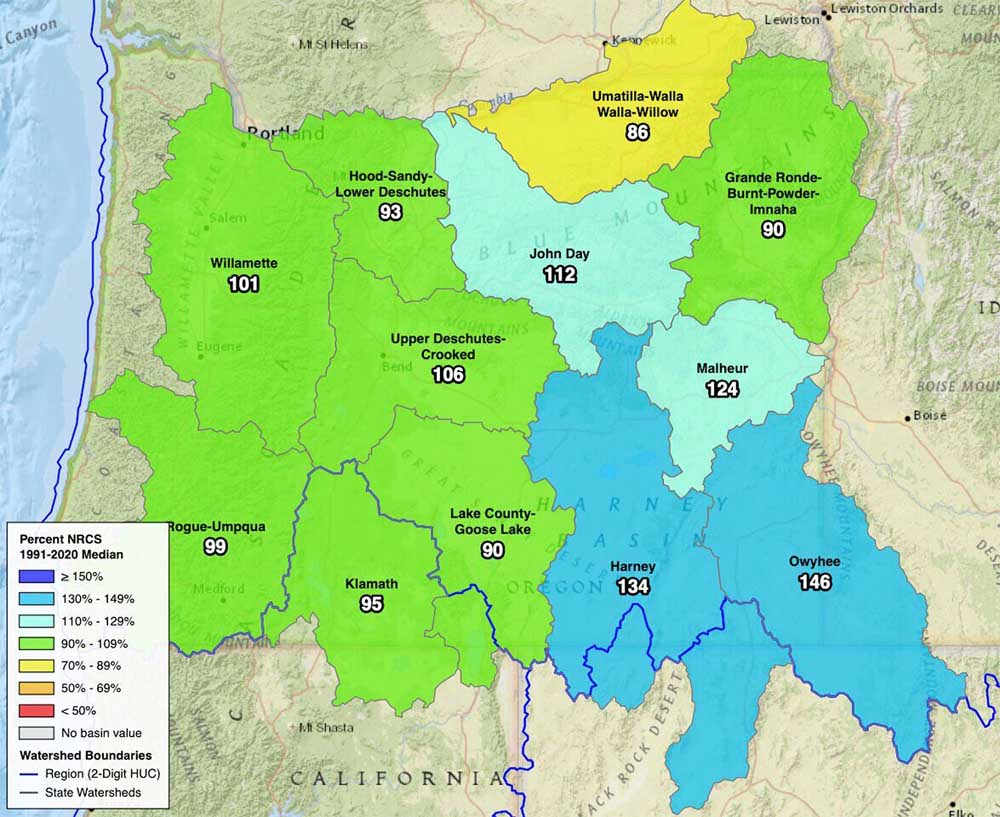
- Snow-water equivalents for Oregon's basins.
SALEM — As snow fell on much of Oregon on Friday, March 1, the state’s snowpack looked to be in good shape, causing early-season water worries to evaporate.
Trending
The average snow-water equivalent for the state’s 12 regions was 106% of the median for the years 1991 to 2020, according to the USDA National Resources Conservation Service.
Washington drifts into ‘snow drought;’ water outlook turns drier
Owyhee Reservoir outflows increased early
Wet fall provides relief from drought in NE Oregon
Trending
Upper Snake snowpack low, reservoirs high
Oregon snowpack surges with storms
Only two regions had a snow-water equivalent below 90% of normal for that date, and half of the other regions were above 100%.
The health of the snowpack will be defined by measurements a month away on April 1, when it should be at its peak.
“Right now, we’re on track for a good, normal snowpack season,” said Larry O’Neill, state climatologist.
But the snowpack needs to keep building, as many areas are only at 70% of the total needed by next month, O’Neill said.
Even if Oregon’s snowpack reaches normal levels April 1, it’s still vulnerable to a dry and warm spring. In 2021 and 2023, a strong snowpack melted out early in many regions.
Though the outlook has improved, including for river flow forecasts, areas including Central Oregon and the Klamath basin still have the potential for drought this summer, O’Neill said.
Weather forecast
The storm hitting Oregon this weekend could stick around, with snow predicted near Cascade ski resorts through March 7, and a wintry mix of precipitation forecast for the Willamette Valley through March 5.
The National Weather Service on March 1 issued a winter storm warning through the morning of March 2 for the Coast Range and much of Southern Oregon, predicting 3 to 7 inches of snow above 1,000 feet of elevation.
A winter weather advisory for the Cascade Range predicted 6 to 10 inches of snow above 2,500 feet before 4 p.m. March 2, as well as gusts of 35 mph.
Early concerns
Snowmelt helps to fill streams and rivers for farms and fish. In general, less snowpack means earlier low summer flows, which could result in earlier water restrictions.
El Nino years tend to be warmer than usual, which can melt snow earlier.
Heading into 2024, the snowpack was near record lows in Oregon, but January storms dumped feet of snow in mountain ranges.
The snowpack declined rapidly afterward and the long range forecast was looking for warmer and drier conditions than usual.
However, atmospheric rivers swept down from Alaska.
“It’s not what’s expected, but we’ll take it,” O’Neill said.
Washington has been left out of the colder, wet weather patterns and its snowpack remains lean, spawning concerns about intensifying drought, O’Neill said.
Region by region
Oregon’s Owyhee River region, which stretches into Idaho and Nevada — several basins dip into neighboring states — was at 146% of normal snow-water equivalent for March 1.
The Harney region was at 134%, followed by:
• Malheur basin, 124%.
• John Day basin, 112%.
• Upper Deschutes and Crooked River basins, 106%.
• Willamette River basin, 101%.
• Rogue and Umpqua basins, 99%.
• Klamath region, 95%.
• Mount Hood, Sandy River and Lower Deschutes region, 93%.
• Lake County and Goose Lake area, 90%.
• Grande Ronde, Burnt, Powder and Imnaha region, 89%.
• Umatilla, Walla Walla and Willow region, 86%.


-
eEdition

-

-
