Falls Fire surges to 55,000 acres; evacuation notices issued in parts of Grant and Harney counties
Published 12:18 pm Sunday, July 14, 2024
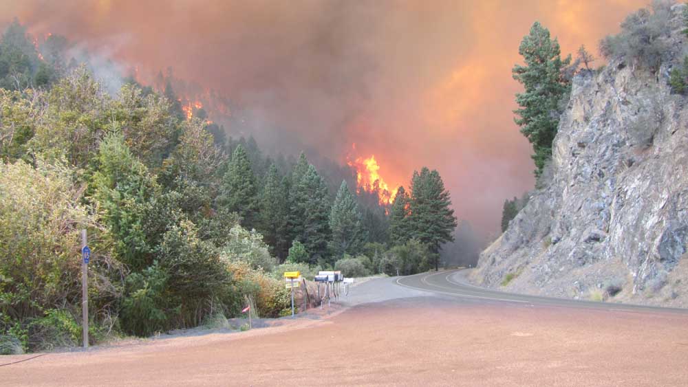
- The Canyon Creek Complex fire makes its way through the Oregon Highway 395 corridor.
HINES — The Falls Fire grew rapidly on Saturday, July 13, surging to 55,000 acres with zero containment, more than 10 times its size on Friday, fire managers reported.
Trending
Evacuation notices have been issued in parts of Grant and Harney counties. For the most accurate evacuation information, please visit the Harney County Sheriff’s Office evacuation map here at https://tinyurl.com/3zst4sjy, or the Grant County Emergency Management Facebook page at https://www.facebook.com/profile.php?id=100068819321423.
Due to fire conditions, the following area is at Level 3: South of USFS 37 & 3750 & 31 Rds. West of 31 & 3120 Rds; Hay Cr & Silvies River; USFS 43 Rd & 47 Rds. .
Debido a los incendios, la siguiente área está en Nivel 3: South of 37 & 3750 & 31 Rds. West of 31 & 3120 Rds; Hay Cr & Silvies River; USFS 43 Rd & 47 Rd. .
Level 3 means go now — leave immediately.
A community meeting will be held at 6:30 p.m. Sunday, July 14, at the Harney County Chamber of Commerce, 484 North Broadway Avenue in Burns.
Trending
The eastern and southeastern flanks were the most active portions of the fire Friday. Westerly and northwesterly winds pushed the fire across Forest Service Road 37 and to the confluence of Myrtle Creek and Silvies River. To the south, the fire has reached Skull Creek Road. Crews were able to hold the fire along FSR 43. Along the north, crews were also able to hold the fire along FSR 4780.
Isolated lightning and thunder were observed in the northeast portions of the large smoke column generated over the fire area. Crews worked throughout the night holding control lines, engaging the fire directly when it was safe to do so, and scouted for opportunities to establish indirect control lines ahead of the fire.
Two helicopters, six single-engine air tankers, two large air tankers, and two very large air tankers supported firefighters Saturday as they made progress securing containment lines on the fire’s north and south flanks along FSR 43.
Similar fire behavior is expected again Sunday. Rapid fire growth is likely given the forecasted weather and fuels conditions. Firefighters will work to hold the fire along established control lines along the western and southern flanks. Crews will continue to scout for opportunities to create indirect control lines and protect values at risk ahead of the fire along the northern and eastern flanks.
Ten hand crews, 16 fire engines, five bulldozers, and six water tenders are assigned to the fire. Additional resources are also responding to the incident and more resources have been ordered.
A Red Flag Warning remains in effect for Sunday with temperatures in the mid-90s and very low relative humidity. Winds will prevail from the west and southwest from 8-10 mph. Afternoon thunderstorms are predicted for the area which may produce gusty outflow winds reaching 20-25 mph. Little to no precipitation is expected from these isolated thunderstorms.
The Malheur National Forest issued an updated fire area closure Saturday, July 13. Emigrant Creek Campground, Falls Campground, Yellowjacket Campground, and Delintment Lake Campground are closed. A detailed map and additional information about the fire area closure are available at https://www.fs.usda.gov/detail/malheur/news-events/?cid=FSEPRD1188914.
A temporary flight restriction remains in place over the fire area.
Marketplace


-
eEdition

-

-
