Falls Fire slows; now at 114,000 acres and 10% contained
Published 9:27 am Friday, July 19, 2024
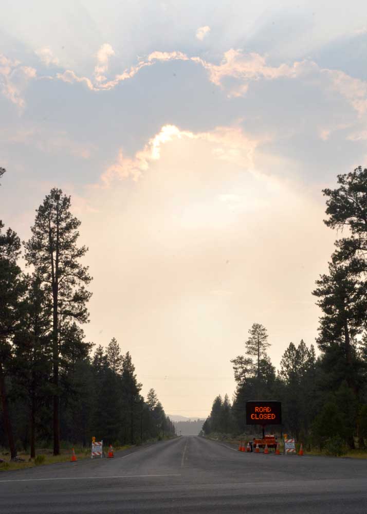
- Smoke from the Falls Fire hazes the sky over the Izee-Paulina Highway looking west from Highway 395 on July 16, 2024.
HINES — The Falls Fire slowed somewhat on Thursday, July 18, adding fewer than 4,000 acres as a persistent heavy smoke layer kept wind and temperatures lower over the fire area and crews on both the day and night shifts worked to establish control lines and minimize fire growth, fire managers reported in their daily update on Friday, July 19.
The blaze now covers 114,236 acres and is 10% contained. It is burning approximately 13 miles north of Burns, 11 miles southwest of Seneca, 7.5 miles south of Izee, and 3 miles west of Highway 395, fire managers said.
Thursday, firefighters on night and day shift took advantage of moderated fire behavior to make headway on new line construction and continue mop-up operations.
In the northwest area of the fire, resources were able to construct direct line with hand crews over to Burnt Mountain. Other direct dozer line work occurred along Forest Service Road 68 to secure small spot fires. A tree felling module worked along FSR 68 in preparation for planned tactical burnout operations intended to reinforce control lines by removing unburned fuel between the fire edge and control lines.
Fire crews and equipment continued to establish control line along the northern flank of the fire where conditions allowed for safe operations. In the northeast corner, the two spot fires that started Thursday on the east side of FSR 31, just south of Myrtle Park Meadows, resulted in about a 200 acre slop-over. Crews and dozers worked to build line to tie it back into FSR 31. Mop-up operations have begun on the slop-over.
At the southeastern corner of the fire, dozer line construction is nearly complete and holding and mop-up operations are underway. Control lines along much of the south and west portions of the fire, along FSR 43, continue to hold firm as mop-up operations continue.
Throughout the northern and eastern edges of the fire OSFM task forces continued structural prep and tactical patrols, and building upon progress made during day shift.
In conjunction with wildland resources, Oregon State Fire Marshal crews are providing structural protection around the clock to the communities of Izee, Silvies Valley Ranch, Seneca, Lone Pine, and the surrounding areas. These crews are utilizing a combination of tactics to minimize the risk to structures.
Structure crews support wildland operations during construction of dozer line and strategic firing operations. They perform structural triage and surface prep. Surface prep includes mitigation tactics such as clearing away receptive fuels and relocating flammable items to areas outside the preparation perimeter. Additional structure crews are conducting point protection of homes, tactical patrols along the edge of the fire and expanding scouted areas.
Friday, in the northwest corner of the fire, operations will continue constructing and securing direct dozer line along FSR 4785, as well as an alternative contingency line on FSR 4781 out to Snow Mountain. Dozer work will also continue along FSR 68.
Along the eastern portion of the northern flank of the fire, dozer and handline will be constructed with the objective of tying in line around Burnt Mountain. Crews will continue to hold, improve, and mop up control lines along the westerly and southern areas of the fire.
On the northeastern portion of the fire, just south of Myrtle Park Meadows, work will continue on the two-day-old, 200-acre slop-over. In the southeast corner of the fire, work will continue on securing dozer line and mopping-up hotspots in the Red Hill area.
Friday morning, two California Office of Emergency Services strike teams joined OSFM task forces and continued structural prep and tactical patrols throughout the northern and eastern edges of the fire, building upon progress made during day shift.
Friday, fire weather is predicted to be similar to Thursday — warm but less windy, being influence by a persistent heavy smoke layer. These conditions may moderate fire behavior and help firefighters to make progress on containing the fire.
Temperature highs may reach 97 degrees and humidity will be low. A Heat Advisory is predicted for the area starting Saturday and extending into Monday with temperatures possibly over 100 degrees.
Evacuation notices remain in effect in Grant and Harney counties. For the most accurate evacuation information, please visit the Harney County Sheriff’s evacuation map here: https://tinyurl.com/3zst4sjy, or the Grant County Emergency Management Facebook page at https://www.facebook.com/profile.php?id=100068819321423.
The Malheur National Forest has issued a fire area closure. A detailed map and additional information about the fire area closure are available at: https://www.fs.usda.gov/detail/malheur/news-events/?cid=FSEPRD1188914.
A temporary flight restriction remains in place over the fire area.
U.S. Forest Service fire investigators are seeking the public’s assistance with any tips or information pertinent to the start of the Falls Fire on the Malheur National Forest. Please submit any information that could assist fire investigation efforts to SM.FS.R6TipHotLine@usda.gov.
Size: 114,236 acres
Start Date: July 10
Location: 13 Miles NW of Burns
Containment: 10%
Total Personnel: 1,588
Cause: Human-caused, under investigation
Structures Triaged: Residences: 228; Commercial: 37; Outbuildings: 349
Resources Assigned: 48 hand crews, 61 engines, 27 bulldozers, and 25 water tenders
Aerial resources available: two helicopters, and four single-engine air tankers
Facebook: https://www.facebook.com/p/Falls-Fire-2024-61562126623985/
InciWeb: https://inciweb.wildfire.gov/incident-information/ormaf-falls-fire
Fire Information Line: 541-208-4370, staffed 8 a.m. to 8 p.m.
Email: 2024.Falls@firenet.gov
Harney County non-emergency evacuation questions: 541-589-5579
Air quality questions: 541-573-2271