Malheur National Forest closes lands near Rail Ridge Fire
Published 2:28 pm Tuesday, September 3, 2024
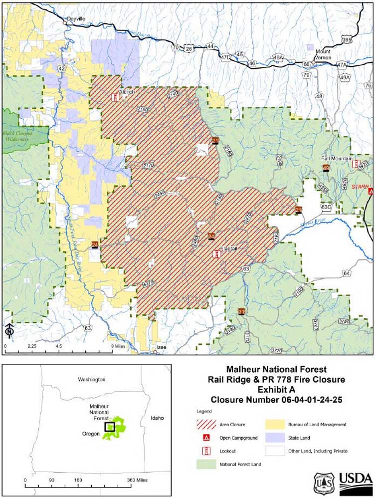
- malheur closure map 240903
DAYVILLE — The Malheur National Forest has issued an area closure for the Rail Ridge and PR778 fires on the Blue Mountain Ranger District.
To protect public health and safety, fire managers announced, they have closed the area described below due to fire activity and fire suppression operations. This closure will be in effect until further notice.
The closure covers the following area:
• Starting at the National Forest boundary on Fields Peak Road/Forest Service Road 21 on the border of T13S, R28E, Sec 35 and T14S, R28E, Sec. 1 south along Forest Service Road 21 to T15, R29E, Sec. 18.
• Along Forest Service Road 21 east and south to the National Forest Boundary in T15S, R30E, Sec. 29.
• Following the National Forest boundary south to Grant County Road 63 on the border of T16S, R29E, Sec. 12 and T16S, R30E, Sec. 7.
• Continues southwest along Grant County Road 63 to the border of T16S, R29E, Sec. 31 and T17S, R29E, Sec. 6.
• Following the National Forest boundary west to T17S, R28E, Sec. 7, north to T13S, R27E, Sec. 33, east to Fields Peak Road/Forest Service Road 21 on the border of T13 S, R28E, Sec 35 and T14S, R28E, Sec. 1.
A detailed map of the closure can be viewed on the Malheur National Forest website at https://www.fs.usda.gov/malheur.