Rail Ridge Fire now 61,000 acres with zero containment
Published 6:44 pm Tuesday, September 3, 2024
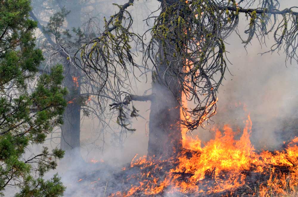
- Flames claim a tree on the Falls Fire's leading edge on July 16, 2024.
DAYVILLE — Several lightning-sparked wildfires in Grant and Crook counties have now merged into a single blaze covering more than 61,000 acres, fire managers announced on Tuesday, Sept. 3.
Trending
The Rail Ridge Fire is located on the South Fork of the John Day River near Martin Creek. The fire jumped from the west bank to the east bank of the river Monday and moved into the Murderers Creek drainage, where it continued to increase in size. Evacuations for all of Aldrich Mountain were enacted, fire officials said.
Several lightning-caused fires combined to become the Rail Ridge Fire. Wildfires designated as the 778 Fire, 761 (Rail Ridge) Fire, 779 (Powell) Fire, and 796 (Black Canyon) Fire are now being managed as one wildfire response.
Full suppression strategy will be used where possible and with firefighter and public safety in mind. The Southern Area Gray Incident Management Team, led by Incident Commander Mitch Ketron, assumed command of the fire on Tuesday, Sept. 3, at 1 p.m.
Trending
Along with firefighter safety, public safety is very important in managing this fire, officials said. If a resident is not already signed up for evacuation alerts, they can contact their local county sheriff’s office.
After a lightning storm moved through the area on Monday, causing multiple fire starts, local resources quickly responded, officials said. This includes multiple federal, state, and rural fire protection resources. Wind associated with the storm system caused the fire to spread quickly though the dry brush and grass.
On Tuesday, firefighters strengthened structure protection along the perimeter of the fire. They utilized natural barriers and existing roadways, and established fuel breaks to begin securing the perimeter of the fire.
Conditions were very smoky, but some air operations were still possible. A flight of the fire’s perimeter was done to find the current acreage. Fire in many of the grassy areas went out as it hit existing barriers. Areas with thicker brush and timber continue to show fire activity.
Weather predictions for the next several days are calling for a warming and drying trend, which means that fuels will continue to dry out, further increasing the likelihood of new ignitions and active fire behavior.
Evacuations: On the north side of the fire, a Level 3 “Go Now” alert has been extended south of Murderers Creek to Cougar Creek Gulch and east to Shake Table.
In the southern part of the fire zone, a Level 3 “Go Now” evacuation advisory was issued for the area west of South Fork Road to the Crook County line and south to the Izee-Paulina Highway.
A Level 2 “Be Set” alert has been issued for the area south of Wickiup Creek in the north, to Fields Creek in the east, to Murderers Creek in the south, and west to Shake Table. That evacuation zone has been extended and now also includes everything north of Forest Service Road 6370 and FSR 24 and the area east to FSR 21.
A Level 1 “Be Ready” advisory has been issued for the area north of the fire to Highway 26, including Dayville, east to Fields Creek and south to Wickiup Creek.
A second Level 1 “Be Ready” evacuation notice has been issued on the south side of the fire zone, from the Crook County line north of Swamp Creek Lane and south of the Izee-Paulina Highway and running northeast to FSR 24.
For regular updates, visit the Grant County Emergency Management Facebook page at https://www.facebook.com/p/Grant-County-Emergency-Management-100068819321423/; call the information line at 541-575-2885; or email the Emergency Operations Center at GCEOC@grantcounty-or.gov.
Visit the Oregon Department of Emergency Management website to view a map of active fires (and evacuation areas) at https://oregon-oem-geo.hub.arcgis.com/.
Closures: The Malheur National Forest has enacted a closure order for sections of the Blue Mountain Ranger District for public safety.
Fire Restrictions: All public lands in Central Oregon, including the Ochoco National Forest, are in Stage 2 Public Use (Fire) Restrictions. All open fires, including woodstoves and charcoal briquette fires, are prohibited.
Malheur National Forest Fire Restrictions can be viewed on the forest’s website.
For more information, visit CentralOregonFire.org or the Ochoco National Forest’s website. Smoke from the Rail Ridge Fire continues, and maps and air quality information are always available on https://fire.airnow.gov/. Please help firefighters by following all local regulations, found here: https://www.oregon.gov/odf/fire/pages/restrictions.aspx. Additional wildfire prevention tips are available at www.keeporegongreen.org.
If you fly, we can’t: Unauthorized drone flights (UAS) pose serious risks to firefighter and public safety and the effectiveness of wildfire suppression operations. Aerial firefighting is suspended when unauthorized UAS are in the area, allowing wildfires to grow larger.
Fire officials urge everyone to do their part to avoid human-caused wildfires. Human-caused fires are avoidable whereas naturally occurring fires are not. Remember, one less spark means one less fire that could put our wildland firefighters and communities at risk.
Size: 61,433 acres
Location: South Fork of the John Day River near Martin Creek
County: Grant, Crook
Start Date: Sept. 2, 2024
Containment: 0%
Cause: Lightning
Total Personnel: 100
Marketplace


-
eEdition

-

-
