Rail Ridge Fire now 50% contained, 162,000 acres
Published 9:30 am Thursday, September 19, 2024
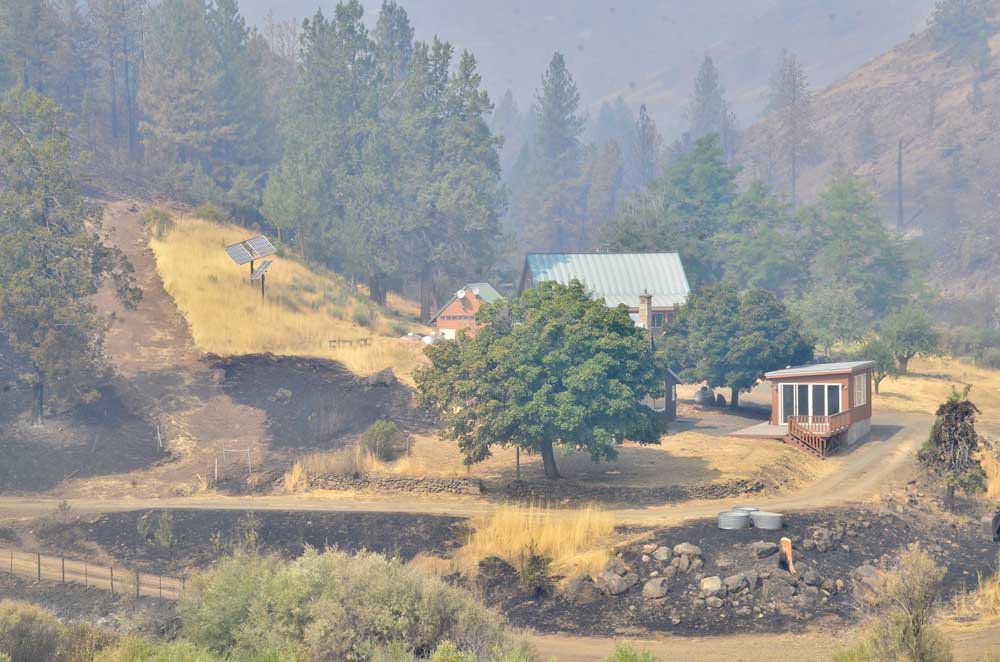
- A burn-scarred landscape shows how close flames from the Rail Ridge Fire came to this home on Sept. 4, 2024.
DAYVILLE — Firefighters extended containment lines around the Rail Ridge Fire as a new team prepared to take over management of the suppression effort, fire managers announced in an update on Thursday, Sept. 19.
Trending
The fire burning just south of Dayville covers 162,000 acres and is now 50% contained, with 1,182 personnel assigned to battle the blaze.
Thursday is the final day California Interagency Incident Management Team 10 will be in command of the Rail Ridge Fire. Alaska Incident Management Team 3 is shadowing and will assume command on Friday.
Firefighters on the north and northeast sides will take advantage of the continued favorable conditions and focus on strengthening existing suppression lines and completing new ones, including working on shaded fuel breaks and clearing fuels.
Trending
On the east side between Shake Table and Forest Service Road 21, crews will continue to work on road repair, grading roads, and repairing the impacts of suppression efforts where needed. On the southern and southeastern portions, crews will monitor and patrol for any heat sources and implement suppression repair.
Throughout the fire area, firefighters will continue mop-up efforts, going deeper inside fire lines to eliminate residual heat as large logs and dead, downed trees continue to burn.
Seasonably warm and dry weather is forecast for the area with lower humidity (25-30%) and sunny skies. Wind will be generally light with gusts up to 15 mph on the ridgetops.
These conditions will allow heavy fuels to continue to burn, which will result in slightly increased smoke production, but there remains no threat to containment lines.
Closures and Evacuations
The U.S. Forest Service and Bureau of Land Management have implemented partial closures because of the Rail Ridge and Crazy Creek fires, for all uses. For more details and closure maps, visit the Ochoco National Forest, Malheur National Forest, and BLM web pages.
Grant County evacuations were downgraded Wednesday. For up-to-date evacuation information, please visit:
• Grant County Emergency Management Facebook page.
• Crook County Emergency Management website or Crook County Sheriff’s Office Facebook page.
• Wheeler County Sheriff’s Office Facebook page.
Acres: 162,345
Crews: 29
Containment: 50%
Engines: 64
Detection Date: Sept 2, 2024
Cause: Lightning
Dozers: 17
Total resources: 1,182
Helicopters: 2 Type 1, 1 Type 2, 1 Type 3
Marketplace


-
eEdition

-

-
