Rail Ridge Fire tops 175,000 acres; containment holds at 89%
Published 11:53 am Tuesday, October 15, 2024
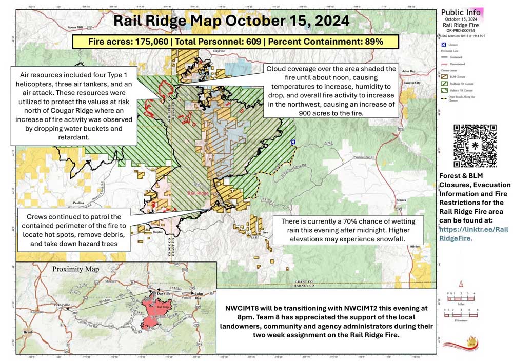
- rail ridge fire map 241015
DAYVILLE — The Rail Ridge Fire grew by nearly 1,000 acres, driven by gusty winds and dry conditions, fire managers said in an update on Tuesday, Oct. 15.
Trending
The fire burning south of Dayville is now just over 175,000 acres and remains 89% contained. A total of 609 personnel are assigned to combat the blaze.
The Northwest Complex Incident Command Team 8 will hand off control of the firefighting effort to Northwest Complex Incident Command Team 2 Tuesday at 8 p.m. Team 2 personnel arrived Monday to begin the transition process.
On Monday, winds and dry conditions caused the fire near Cougar Ridge to increase in activity, causing significant increase of smoke throughout the day, fire managers said. Strong winds with gusts up to 20 mph were flowing from the southwest, before shifting to the northwest in the late afternoon.
Trending
Cloud coverage over the area shaded the fire until about noon, causing temperatures to increase, humidity to drop, and overall fire activity to increase in the northwest. An infrared flight overnight showed the fire increased by 900 acres.
Air resources included four Type 1 helicopters, three air tankers, and an air attack. These resources were utilized to protect the values at risk north of Cougar Ridge, where an increase of fire activity was observed, by dropping water buckets and retardant.
Heavy machinery and crews continued to establish containment line on the northwest section of the fire. Crews continued to patrol the contained perimeter of the fire to locate hot spots, remove debris, and take down hazard trees.
While some crews have been moved to the northwest of the fire to assist in containment, fire personnel continued to diligently work on repairing roads throughout the burn area, including Forest Service Roads 2150 and 24.
Tuesday, expect to see similar fire activity. Fire behavior is expected to increase once the smoke inversion lifts early in the day. Winds will flow in from the southwest in the morning and shift to come from the northwest by evening. Firefighters are expecting to see an increase of torching and spotting in the heat of the day in the northwest.
A change of weather is expected, with meteorologists expecting a 70% chance of wetting rain Tuesday after midnight. In the highest elevations, this precipitation may appear as snow.
Heavy machinery is still being used on the northwest perimeter to establish containment line along FS Road 3850. Fire managers are evaluating the terrain and infrastructure north of the containment lines on the active piece of the fire to install contingency lines.
Crews will continue mop-up and suppression repair along contained edges of the fire. Air resources will continue to be used as needed.
High pressure will push east later Tuesday as low pressure pushes in from the west. Expect increasing clouds by later in the afternoon through Tuesday evening and a chance of rain after midnight.
There will be a few hours of dry conditions Tuesday afternoon with minimum relative humidity down to 25%, then quickly rising in the evening. Winds will be out of the southwest Tuesday afternoon and turn west-northwest Tuesday evening with gusts of 12-15 mph.
Temperatures will likely dip below freezing Wednesday night into Thursday, and light snow will be possible above 4,500 feet elevation.
Forest visitors near the Rail Ridge Fire should be aware that Forest Service and BLM closures as well as fire restrictions around the Rail Ridge Fire remain in place.
For the latest information on Forest Service and BLM closures, evacuation notices and fire restrictions for the Rail Ridge Fire area, go to https://linktr.ee/RailRidgeFire.
Rail Ridge Fire at a Glance
Acres: 175,060
Containment: 89%
Detection: 09/02/24
Cause: Lightning
Personnel: 609
Marketplace


-
eEdition

-

-
