In the mountain’s shadow
Published 1:00 pm Friday, May 20, 2022
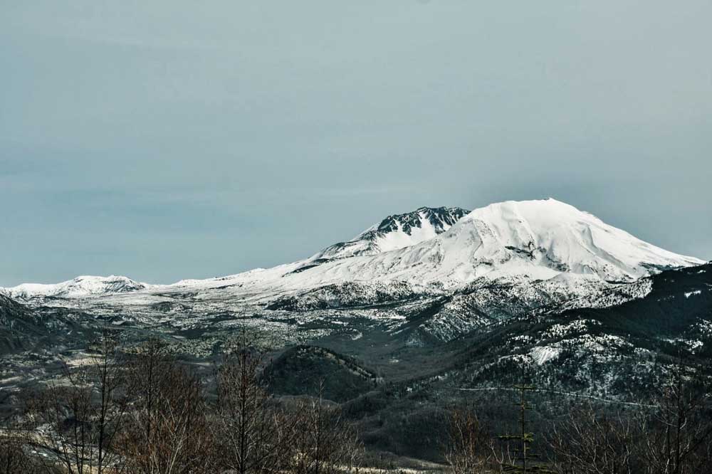
- A snowcapped Mount St. Helens.
ASTORIA — According to the Klickitat people, the creator had spoken. He was furious with his sons, who led his people to opposite sides of the great river.
Wy’east and Pahto led warriors against one another over the love of Loo-wit, a woman who could not decide between the two. Seeing his people perish at the hands of their own kin, the creator flew into a rage, casting all three into stone in the form of the great fire mountains that dominate the horizon, so the legend tells.
The Cowlitz, Yakama, Multnomah and Chinook tribes gave their own names and stories to the towering peaks. When Capt. George Vancouver entered the Columbia, he gave two of them names that he thought would serve him best in the British Royal Navy.
Wy’east became Mount Hood, after Adm. Samuel Hood, and Loo-wit became Mount St. Helens after the ambassador to the Spanish court Baron St. Helens. Pahto, now known as Mount Adams, would wait another 70 years to take the name of the United States’ second president.
Mountains have captured the imagination and awe of humankind since the dawn of time. Nearly every culture has ascribed some spiritual significance to the peaks in their realm. Often, a mountain serves as the setting of a creation story, or some physical manifestation of a spirit, god or goddess. For lower Columbians, Mount St. Helens is a constant presence, whether you can see the mountain or not. On a clear day, it can be seen from nearly anywhere on the river, sporting varied cloaks. It reigns over the landscape, silent and peaceful for now.
The catastrophic eruption of May 18, 1980, changed everything. The classic Cascadian dome, considered by many to be the most beautiful of the Cascade stratovolcanoes, was blown off in one of the deadliest and most destructive volcanic events in American history. This was not the first time the mountain had blown its top. Geologic records reveal many more, and many Indigenous tribes have told stories about its fiery events. Not many alive at the time will forget where they were when the mountain lost its temper.
Most lower Columbia locations had a dusting of fine, gritty ash, but the blast was to the north and the prevailing winds buried the lands northeast of the blast zone in as much as 5 inches of ash. The blast zone was devastated. Trees were incinerated in seconds and millions of logs from surrounded forests washed down the Toutle and Cowlitz rivers before filling the Columbia, along with a mixture of ash and pyroclastic mud.
Life downstream was forever changed. River commerce came to a stop for a time. The incalculable damage resulted in years of dredging, construction and countless human and financial costs before the Columbia returned to its pristine state. Having spent many school days in Longview, Mount St. Helens was always right over our shoulders, in winter dazzling white and in summer stripped and bare.
Spirit Lake, lying at the base of the mountain, was a summer destination for kids from all over the Northwest for decades. Scout troops and recreation groups had regional camps there, in addition to a host of public and private campsites and lodges. The shores and close waters were loaded with canoes, rafts and floats. In the evening, campfire smoke mingled with singing, laughter and scary stories over hot dogs, marshmallows and hot chocolate.
This spring, two events spurred me to take a day drive to the mountain. First, to celebrate the 50th birthday of my Volkswagen bus, and also to reminisce about an adolescent foray to the mountain in 1972.
It’s a great day trip for those living on the lower Columbia. From U.S. Highway 30 and Interstate 5, head toward Kelso before turning east at state Route 504 near Castle Rock. In the 1970s, Spirit Lake Highway was a twisting, narrow road often traveled by logging trucks. After the blast, the road had to be rebuilt for years, since much of it was simply buried. Today it’s a pleasant drive of long curves and grades.
The names swirl in my memory as I drive, first Seaquest State Park. Then Silver Lake, where I nearly drowned while learning to water ski. The town of Toutle, home of the Toutle Lake High School Fighting Ducks. Kid Valley Store, where everyone stopped to get that one thing they forgot. My one disappointment in the trip was to find a “Road Closed Ahead” sign at the turnoff to Tower Road. Before the eruption, two places on this road were the old swimming holes of every youth within 50 miles. The Tower Bridge, with its pools and cliffs, entertained young and old alike with cold, crystal clear waters and wind protected beaches, all just a few miles from town.
Upstream of the bridge was Hollywood Gorge, where a locomotive once plunged off a trestle into the river, a 1930s film stunt. Downstream was another favorite swimming hole. Though the river still flows through these places, they are forever changed since the eruption. Once past the town of Toutle, the highway begins to rise quickly in elevation.
Above Toutle, Washington 504 is a seasonal highway, closed and unplowed from November until May. In the summer, the road is open all the way to the Johnston Ridge Observatory, which offers spectacular views of the crater. The observatory is open to the public in the summer through late fall, and is the trailhead of many hiking routes. From every viewpoint, it is apparent that the forces entrusted with management of Mount St. Helens made the right decision early, to just leave it alone.
Standing on the ridge that bears his name and gazing into the maw of the crater, you too may swear you can hear the last words of David A. Johnston, the vulcanologist who perished there in the disaster, “Vancouver! Vancouver! This is it!”


