JOURNEY: Daytripping in Grant County
Published 10:15 am Thursday, July 29, 2021
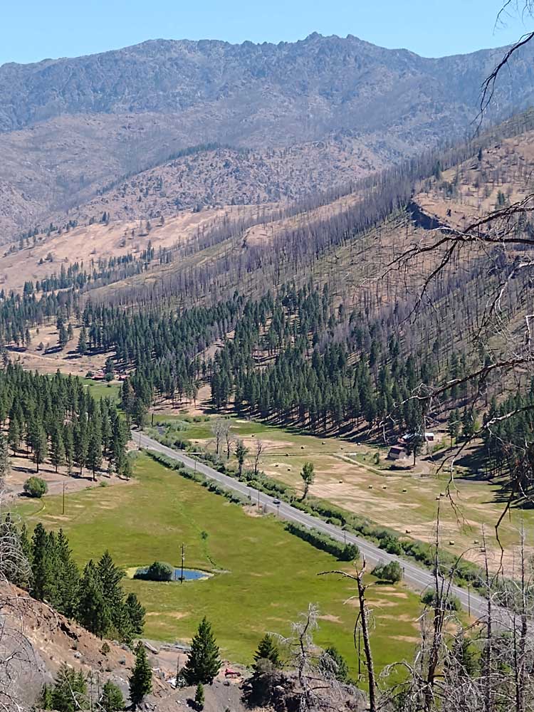
- Highway 395 winds down from Starr Ridge Summit, revealing impressive views of Canyon Mountain and the valley below.
When it comes to scenery, Grant County seems to have it all.
Rushing rivers, lush valleys, pristine lakes, towering mountains, deep forests — varied landscape is one of our area’s most valuable assets.
And to top it off, it’s all easily accessible.
Two highways — 395 and 26 — split the county nicely into four quadrants. From these major roadways, several connecting smaller ones provide convenient loop routes to just about all corners of the county. No dead-end roads or backtracking necessary!
So what are you seeking? Whether it’s scenic vistas, wildlife viewing, fishing, ghost town explorations or a nature hike, you’re bound to find it somewhere in Grant County — and practically right at your doorstep.
Here are a couple of loop routes both locals and visitors will enjoy. Either of these can easily be enjoyed on a Sunday day trip, or take your time for a relaxing weekend venture. And “not just for vehicles only” — these routes are well-suited for motorcycles and bicycles, too. All you have to do is pick a town and a direction, and go!
For each, we’ve laid out the round-trip mileage, communities you’ll pass through and some of the sights along the way. Note that our starting spot and direction is simply for locational purposes as you plan your venture. Obviously, your journey will vary!
Food, gas, supplies and lodging are available in most towns, except as noted. Many areas have plenty of camping options too. Grant County is home to two state parks — Bates, northeast of Prairie City, and Clyde Holliday, just east of Mt. Vernon — and numerous national forest and BLM campgrounds.
Do your homework in advance regarding camping options and business operating hours. And remember, cell service may be limited (or nonexistent) in some areas, so make those plans before you start up your rig.
Grab a map, watch for critters everywhere and don’t forget the camera! Memories and adventures await!
Ghost Towns Galore
Route: Ritter-Prairie City-John Day-Mt. Vernon-Fox-Long Creek (northeast section of Grant County)
Roads: County Road 20 (Middle Fork Road), State Highway 7, U.S. highways 26 and 395
Total loop: 120 miles
Sights:
• Ghost towns: Galena, Susanville, Austin, Bates, Beech Creek, Ritter
• John Day River Middle Fork
• Forest Service campgrounds include Deerhorn and Middle Fork
• Bates State Park
• Sumpter Valley Interpretive Trail
• John Day River
• Clyde Holliday State Park
Side Trip: Magone Lake. At Keeney Fork Road, just a few miles west of Prairie City, head north about 15 miles — all paved — to Magone Lake and campground. Note: Magone is also accessible from the Mt. Vernon area. Ten miles north of Mt. Vernon, turn east on County Road 32, 10 miles — all gravel — to the lake.
If you’re looking for ghost towns, this is the journey for you!
From Highway 395 in northern Grant County — near Ritter — enjoy a leisurely drive along County Road 20, but have your camera ready at just about every turn. This section offers 40 miles of some of the most spectacular scenery Grant County has to offer as the road winds along the John Day River Middle Fork. Enjoy the fruits of restoration efforts this area has undergone in recent years. A pullout at about milepost 11 has interpretive signs explaining the work in the Oxbow Conservation Area.
Along the way are the sites of old gold-mining towns Galena and Susanville. Near the conjunction of County Road 20 and Highway 7, is Bates State Park, the site of logging town Bates, which closed in the mid 1970s. In 2011, the property became a state park, with hiking trails and interpretive signs recounting the history, daily life and memories of Bates.
At Highway 7, our route turns southwest a mile to Austin Junction at Highway 26. But first take a quick jaunt about a mile northeast on Highway 7 to Austin Road, once the location of another ghost town, Austin.
On Highway 26, about a mile past Dixie Butte Pass, watch for the Sumpter Valley Interpretive Trail. This site includes plenty of parking, a restroom and picnic area. An easy gravel trail leads down to interpretive signs and railroad remains of the Sumpter Valley Railway, which ran from Baker City to Prairie City until 1933.
Don’t miss the covered wagon viewpoint about 5 miles before Prairie City for an impressive view of the John Day Valley and Strawberry Mountain Wilderness.
Enjoy a closer look from the valley floor as you continue on Highway 26, following the John Day River through the towns of Prairie City, John Day and Mt. Vernon. Grant County’s other state park, Clyde Holliday, rests right along the John Day River, just a few miles before Mt. Vernon.
At Mt. Vernon, turn north on Highway 395, into the high desert areas of the county. Three passes await — Beech Creek, Long Creek and Ritter. A few scattered buildings remain of Beech Creek before the road heads into the wide open spaces of the small ranching town of Fox. At Long Creek Summit is Carter Rest Stop, before the highway turns toward a spacious overlook view of Long Creek and its valley.
About 13 miles north of Long Creek, just after passing over the John Day River Middle Fork is the junction with County Road 20, the starting point for this route.
Backside of the Wilderness
Route: John Day-Canyon City-Seneca-Prairie City (southeast section of Grant County)
Roads: U.S. Highway 395, Forest Road 16, County Road 62 (Summit Prairie Road), U.S. Highway 26
Total loop: 86 miles
Sights:
• Canyon Creek
• Swick Old Growth Interpretive Site
• Forest Service campgrounds: Starr Ridge, Parish Cabin, Trout Farm and Crescent
• Lake Creek Youth Camp
• Strawberry Mountain Wilderness
• Logan Valley Interpretive Site
• Summit Prairie
• John Day River
Side Trip: Strawberry Mountain trailhead: About 15 miles east of Seneca, drive north on Forest Road 1640 about 11 miles to the Roads End Trailhead. Several hiking options are in this area.
Trivia: The Strawberry Wilderness Range is one of just a few in the United States that run east-west.
Prepare for a true “wilderness” journey — from the comforts of paved roads — on a route that explores the less-traveled backside of the Strawberry Mountain Wilderness.
From John Day, head south on Highway 395 through Canyon City, the seat of Grant County. For about 10 miles, the highway meanders through the canyon, following Canyon Creek and passing Canyon Mountain at the western edge of the wilderness. As the road rises toward Seneca, watch for a couple of noteworthy stops — Starr Ridge Summit and Swick Old Growth Interpretive Site.
At Seneca, turn east on Forest Road 16 toward Logan Valley. Be aware that from here, there are no services for nearly 50 miles until Prairie City. So before leaving Seneca — or Prairie City, if traveling from the other direction — make sure you’re stocked with plenty of gas, food and other supplies.
Almost immediately you’ll know you’ve left civilization behind! Nothing but expansive scenery and breathtaking views await you — and your camera.
Forest Road 16 follows Bear Creek here and later Summit Creek. Check out Lake Creek Youth Camp, available for groups and events. And don’t miss the Logan Valley Interpretive Site, about 30 miles from Seneca. There are no restrooms, but you’ll find just about everything else — an easy pull-out parking area, breathtaking views of the “backside” of the wilderness, wildlife viewing and wildflowers. And at nearly 5,000 feet, it’s a mighty refreshing cool spot in summer.
After about 25 miles, in the spacious and lush Summit Prairie area, turn north on County Road 62 (Summit Prairie Road). Now the venture passes on the east side of the wilderness, and before long, you’ll follow the narrow John Day River, which resembles not much more than a creek as it flows from its frigid start in the wilderness.
The scenery changes to wide open prairie and ranch land. Upon entering Prairie City, Summit Prairie Road turns into Southwest Bridge Street.
Turn west at Highway 26 and enjoy the more familiar “frontside” views of the wilderness and the widening John Day River, while heading toward John Day, and the start of this route. You’ve just circled the entire Strawberry Wilderness Range!


