Crews watch for new starts around Battle Mountain Complex
Published 11:11 am Monday, August 5, 2024
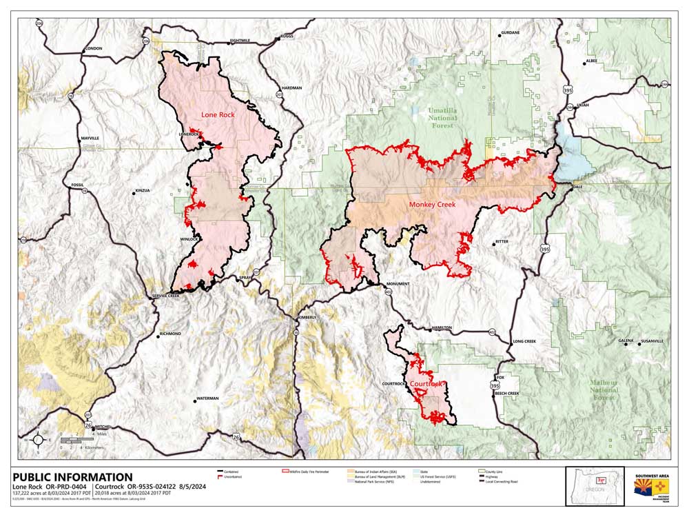
- courtrock fire map 240805
UKIAH — Firefighters on the Battle Mountain Complex expect to contend with new fire starts in the area following thunderstorms that brought some moisture but not enough to knock down all the new blazes, fire managers said in an update on Monday, Aug. 5.
The fire burning in portions of Grant, Umatilla and Morrow counties now stands at nearly 182,000 acres and is 36% contained. More than 1,800 firefighters are assigned to the blaze.
Overnight, fire crews received a mixed bag of weather. Most of the complex saw lightning with roughly 100 down strikes within the fire’s Temporary Flight Restriction (TFR) zone and the team’s area of responsibility. Firefighters also saw wind gusts close to 58 miles per hour, which created low visibility when mixed with ash and dirt, and up to a quarter-inch of rain on the middle and northern portions of the burn.
While the humidity helps moderate fire weather some, it’s not appreciable enough to cool the fire and is expected to drop throughout the day on Monday. Firefighters are on watch as the day heats and smoldering lightning strikes have a higher chance of smoking and revealing themselves, especially as the wind gusts dropped branches from trees and cast needles and other burnable materials.
On Monday, helicopter bucket ships will begin flight operations earlier in the day to patrol for new starts and deliver water for initial attack. Firefighters will be ready to identify new starts and quick to suppress any new fires within the complex, especially with weather in the 90s and more chances of lightning and wind gusts.
Overnight, firefighters pushed containment to 36% as they continued to extinguish lingering hot spots and increased mop-up depth. Overnight, crews used handheld heat-sensing devices to identify and mark hotspots for dayshift crews.
Monday, firefighters will continue work in the Potamus drainage as they bring the fire to control features to stop its advance and begin mop up. Elsewhere, crews will continue mop-up operations around the entire perimeter of the fire and suppression repair work along lines considered fully contained. Suppression repair work consists of burying firelines and diverting runoff to minimize potential soil erosion and environmental impacts.
Residents should continue to expect to see smoke in the interior and the unburnt island within the fire perimeter as unburnt vegetation burns well within the fire’s footprint. Crews will continue to patrol the fire perimeter throughout the summer to check fire behavior and ensure the fire doesn’t escape.
Fire officials invite the public to join them at the Heppner City Hall, 111 North Main Street, at 6 p.m. Monday for a community meeting. Fire officials, public leaders and community partners will share information about current operations and will have time for breakout question-and-answer sessions. This event will be recorded and published after the event.
Evacuations: Learn more about current evacuation levels for each county at:
For Umatilla County, follow www.facebook.com/UmatillaCountySheriff or sign up for Umatilla County Emergency Alert System at https://member.everbridge.net/index/2590041373147145.
For Grant County, visit the RAPTOR arcgis site or sign up for alerts at: https://member.everbridge.net/index/825462649520134.
For Morrow County, visit https://experience.arcgis.com/experience/de78333b0d2544f7a320142174aa20ae
Public Land Closures:
The Bureau of Land Management has closed public lands along the John Day River from Kimberly to Dale, and from Kimberly to Service Creek. More information here: https://www.blm.gov/programs/public-safety-and-fire/fire-and-aviation/regional-info/oregon-washington/fire-restrictions.
The Umatilla National Forest has implemented a closure for public lands within the Heppner Ranger District and the North Fork John Day Ranger District. More information at: https://www.fs.usda.gov/detail/umatilla/news-events/?cid=FSEPRD1194462 and https://www.fs.usda.gov/detail/umatilla/alerts-notices/?cid=stelprdb5286768.
Total Estimated Complex Size: 181,941 acres
Monkey Creek Fire: 177,457 acres
North Fork Owens: 4,484 acres
Total Containment 36%
Cause: Under Investigation
Estimated Cost: $47,439,592
Hand Crews: 59
Engines: 75
Water Tenders: 37
Dozers: 24
Helicopters: 9
Total Personnel: 1,861