Take a Hike
Published 5:00 pm Tuesday, May 21, 2013
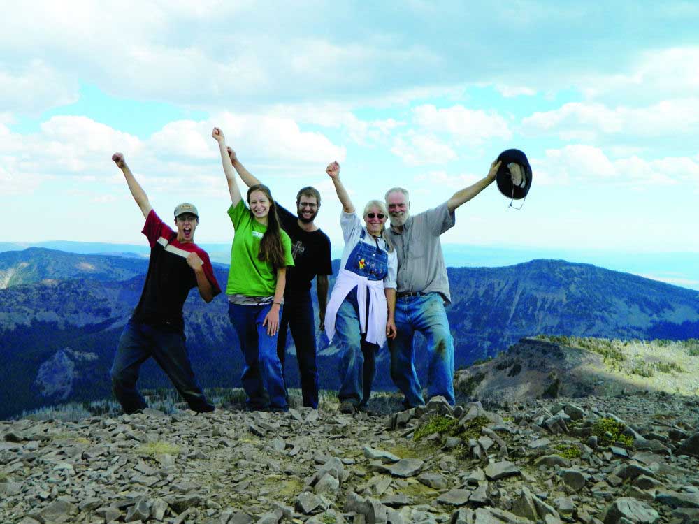
- Atop Strawberry Mountain
Slip on your hiking boots and get exploring …
Trending
There are over 1.3 million acres of non wilderness lands that comprise the Blue Mountain, Prairie City and Emigrant ranger districts, where you will find hundreds of trails and roads to choose from.
EASIEST TRAILS
ARCH ROCK TRAIL – Trail #258, Blue Mountain Ranger District Malheur National Forest (MNF) Open: April – November
Trending
Length: 0.3 miles Elevation: 3,968 – 4,270 Use: Light Hiking: Horses allowed, Mountain Biking and ATVs prohibited.
Arch Rock is an ash flow tuff with a scenic arch and several small rock shelters eroded into the outcrop. Access: From John Day, travel east toward Prairie City on Highway 26 about 10 miles. Turn north onto County Road 18. Go approximately 10 miles to the junction of Forest Service Road 36 and County Road 18. Turn right follow the 36 Road along Camp Creek to Forest Service Road 3650. Drive the 3650 Road to the junction of Forest Service Road 3650-428 where the trailhead is located. This is mostly forested hiking/riding on the lower end of the trail. There are some open meadows that are good for camping. Camping is possible all along the trail with good opportunities for solitude.
ROADS END TRAIL – Trail #201A Blue Mountain Ranger District, MNF Open: July to October Length: 1.5 miles Elevation: 8,000 – 4,270 Use: Moderate Hiking: Horses allowed, Mountain Biking and ATVs prohibited.
Roads End Trail is an easy walk to a spectacular view of the John Day Valley to the north and Bear Valley to the west and south. The entire length of the trail is on an old roadbed. Wildflowers and occasional patches of snow can be enjoyed along this trail during July and August. If you walk up off the trail to the east you can view High Lake. This trail is the first section of the
shortest route to the top of Strawberry Mountain. The end of this trail ties in with the Pine Creek Trail 201 to the west and the Onion Creek Trail 368 to the east. This 3-way intersection is Roads End landmark. It overlooks the Indian Creek Basin which was recently scarred by the Wildcat Fire of 1996.Access: From Seneca, drive east on Forest Service Road 16 for approximately 15 miles to Forest Service Road 1640. Drive north on Forest Service Road 1640 for about 11 miles to the Road End Trailhead. Forest Service Road 1640 does not end here. If you continue driving to the end of Forest Service Road 1640, you will arrive at the Skyline Trailhead 385.
NORTH FORK MALHEUR TRAIL – Trail #381, Prairie City Ranger District, MNF Open: April – November Length: 12.4 miles Elevation: 4,000 – 4,880 Use: Light Hiking: Horses and Biking allowed, ATVs prohibited
North Fork Trail has a foot bridge that crosses the North Fork Malheur River at the trailhead, then goes along the west side of the river. This trail is in the Wild and Scenic River Area.
Access: From Prairie City, take County Road 62 south and turn on Forest Service Road 13, along Deardorff Creek. Then take Forest Service Road 16 south at Short Creek Guard Station, and turn off at Forest Service Road 1675. Follow Forest Service Road 1675 for about 3 miles to the trailhead.
DIFFICULT TRAILS
MALHEUR RIVER TRAIL – Trail #303 Emigrant Creek Ranger District, MNF. Open: April to November Length: 7.6 miles Elevation: 4,400 to 4,620 Use: Light to Medium Hiking: Horses allowed, Mountain Biking and ATVs prohibited.
Malheur River Trail is a National Recreation Trail which offers an enjoyable hike along a portion of the Malheur River. This scenic trail offers good fishing and allows the user access to a
semi-primitive setting.Access: From Seneca, travel 14 miles east on Forest Service Road 16 to Forest Service road 1643. Follow the 1643 Road approximately 10 miles to Dollar Basin. Turn left, travel 1 mile to the Malheur River. The trailhead is 200 feet downstream. Access may be found at Hog Flat, another 8 miles down the 1643 road. Turn onto the 142 road. The trailhead is at the end of the 142 road.
MORE DIFFICULT TRAILS
JOAQUIN MILLER TRAIL – Trail #219 Blue Mountain Ranger District, MNF Open: June- November Length: 6.0 miles Elevation: 5,600 to 7,700 Use: Light Hiking: Horses allowed, Mountain Biking and ATVs prohibited.
Joaquin Miller Trail access is on the southwest end of the Strawberry Mountain Wilderness. The trail leads through a scenic grove of old growth ponderosa pine located on a bench
approximately 2 miles from the trailhead. This stand is part of the Canyon Creek Natural Area which a portion of this trail
borders.Access: From John Day, travel south on US Highway 395 to County road 65. Take the 65 Road south for approximately 4 miles. Turn left onto Forest Service Road 6510. The trailhead is at the end of the road.
MALHEUR RAIL TRAIL – Trail #382, Prairie City Ranger District, MNF Open: May – October Length: 12.5 miles Elevation: 4,000 to 9,038 Use: Light Hiking: Horses allowed, Mountain Biking and ATVs prohibited.
Malheur Rail Trail is located on the former Hines Railroad Grade. Traveling on this trail takes you through steep grades, filled to accommodate railroad traffic, deep cuts through rocky hills and flat, open areas.Access: From Prairie City, take County Road 62 approximately 19 miles to Summit Prairie. From Summit Prairie travel west on Forest Service Road 16 to Forest Service Road 1600133. Travel on Forest Service Road 1600133 to the junction with Forest Service Road 1600097 where the trailhead is located.
Interested in finding other trails in the area? Check out the Grant County Chamber of Commerces web site at www.gcoregonlive.com. Because of differences in elevation, location and other conditions, some trails may open later than others. Malheur National Forest, 541-575-3000 Prairie City Ranger District, 541-820-3800


-
eEdition

-

-
