Mt. Vernon ranchers concerned about erosion on John Day River
Published 1:00 pm Tuesday, June 25, 2024
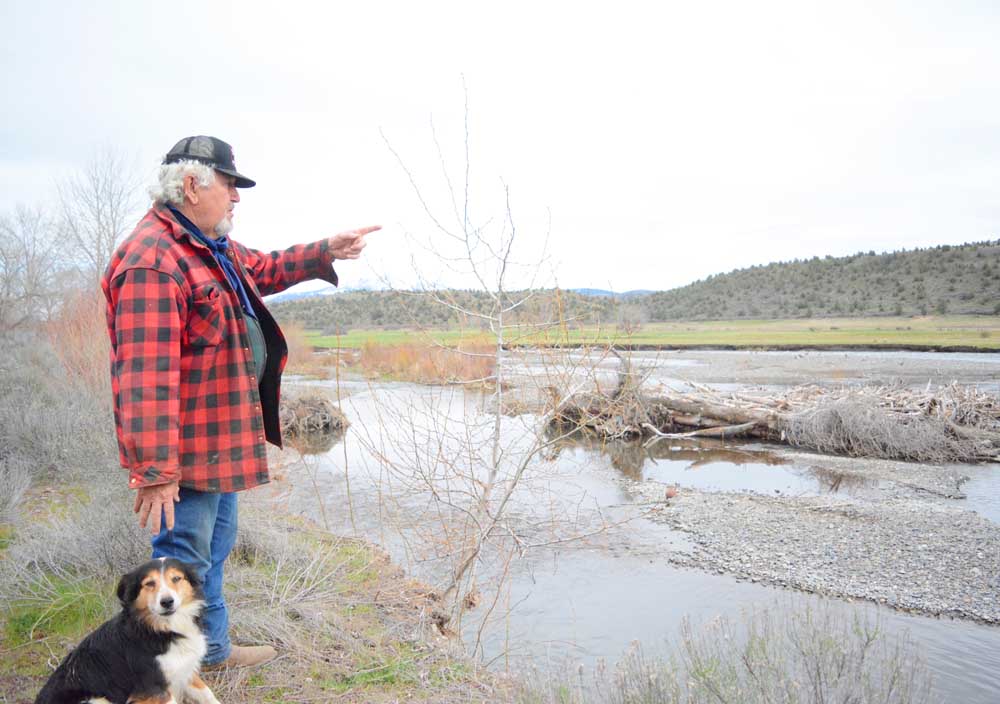
- Lemons is concerned that severe erosion on the John Day River in Mt. Vernon leaves the area vulnerable to property damage from a future flood.
MT. VERNON — Prominent ranchers in Mt. Vernon are expressing concern about the possibility of flood damage to properties south of the John Day River.
The river has been cutting into the bank in the vicinity of the Ingle Street Bridge for at least half a decade, according to locals, and the situation got worse last January, when a heavy snow melt-off widened the river at that point from 50 feet to 500 feet.
Rancher Darrell McKrola said the river has been eating away at his meadow. McKrola said he’s lost a little under 2 acres of land from the river erosion in the last five years.
“I think at that point, where it’s just topsoil, it definitely needs some reinforcement to keep the water from washing that field away,” McKrola said.
“If it continues to eat that meadow out, the river’s going to redirect and go right into town,” he added.
McKrola’s neighbor, Ingle Butte Ranches owner Kim Lemons, voiced his concern to local officials about the possibility of major flooding and potential property destruction along the south side of the river in the city because of the severe erosion.
“This is all filling up with gravel and it’s pushing up the river to the south,” Lemons said. “Every time it floods now, there’s no bank over there, so when the river comes up 6 to 8 feet, it’s going to go right across that meadow and go down to those houses.”
Lemons said local officials should take action to prevent the problem from getting worse.
“By God,” he said, “they better find the money, or if they have to come fix it, it’s going to be 20 times worse, replacing all this stuff.”
After speaking with Lemons and seeing the riverbank changes for himself, Grant County Roadmaster Alan Hickerson said he is concerned that debris from upstream during a flood event could damage the Ingle Street bridge, a county span that crosses the John Day River just west of the severe erosion spot. He said the issue is something the Grant County Road Department “could look into.”
“There’s a lot of debris with that much water going down,” Hickerson said. “With all the erosion, we don’t know where all the water is going to go and what debris it’s going to carry down to the bridge. … The river does go under a county road, and there will be debris going by a county bridge.”
Lemons said it should be a fairly easy fix to bolster the riverbanks with bulldozers and excavators, though officials say permits must be granted by the Oregon Department of State Lands for such work, in addition to securing engineering and funding for such a project.
Richard Fitzgerald, aquatic resource coordinator for the Oregon Department of State Lands, implements the state’s removal/fill law, which regulates the placement or removal of material from waterways or wetlands in Oregon.
Fitzgerald called attention to the efforts by the community of Echo after severe erosion on the Umatilla River destroyed and threatened property in the city in recent years. The city obtained a $75,000 grant from Umatilla County toward flood protection plans and $2 million from the Oregon Department of Emergency Management for flood mitigation.
“The big issue occurred in Echo,” Fitzgerald said. “I think it started in 2020, but they had more erosion on the Umatilla River. What we did was we issued an emergency permit, which we’re able to do when erosion threatens property or life.”
Fitzgerald said an initial fix involved putting in some large rocks along the eroded bank.
“They went back and added some habitat features,” he said. “They finished that work, and we closed out the permit and it seems to have stabilized the site.”
The East Oregonian contributed to this story.