UPDATED: Falls Fire now at 64,000 acres; evacuation notices in effect for parts of Grant County
Published 12:21 pm Monday, July 15, 2024
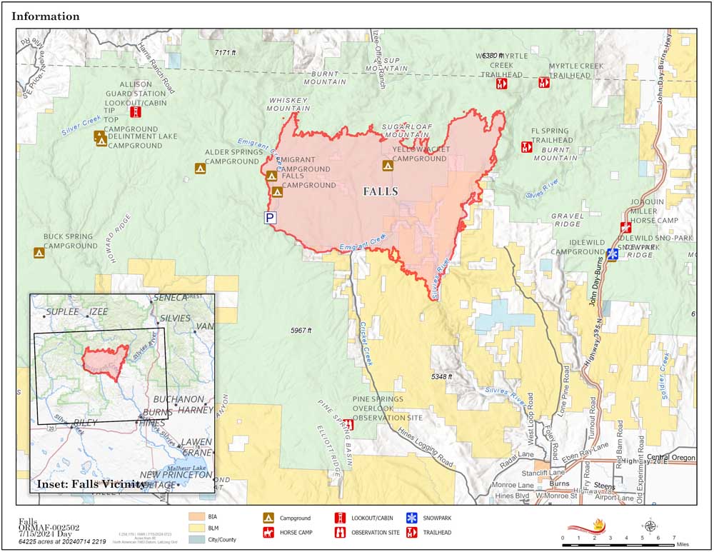
- A map showing the Falls Fire as of Monday, July 15, 2024.
HINES — The Falls Fire continued to grow on Sunday, July 14, but at a slower pace than the day before. The blaze was estimated at 64,225 acres on Monday, July 15, with zero containment, according to the latest update from fire managers.
Trending
The fire is burning approximately 13.5 miles north of Burns.
Evacuation notices remain in effect in Grant and Harney counties. For the most accurate evacuation information, visit the Harney County Sheriff’s Office evacuation map at https://tinyurl.com/3zst4sjy, or the Grant County Emergency Management Facebook page at https://www.facebook.com/profile.php?id=100068819321423.
In Grant County, a Level 3 (go now) evacuation notice is in effect west of Highway 395 from the county’s southern border north to the vicinity of Forest Service Road 31.
Trending
A Level 2 (be set) evacuation notice is in place from there north to the Izee-Paulina Highway.
A Level 1 (get ready) evacuation notice is in place from there to the northern edge of Bear Valley.
Grant County Sheriff’s Office personnel have been patrolling the area around the fire zone for the past few days, making sure people living or camping in the area are aware of the danger and the evacuation level where they are, according to the county’s emergency management coordinator, Eric Bush.
“The good news is it’s a really sparsely populated area, and we know where people camp,” Bush said. “We’ve actually had people out on the ground in that area every day.”
As of 8:30 p.m. Sunday, the Oregon State Fire Marshal’s Blue Team and Northwest Incident Management Team 8 have joined into unified command for the Falls Fire. This collaboration allows for wildland and structural fire resources to work together under a unified direction while focusing on their different missions.
On Sunday, the significant fire growth was along the northeast and northwest corners of the fire. Firefighters continued to hold the western edge of the fire along Forest Service Road 43. Spot fires over the 43 road from the night before were lined and firefighters put in hose lays to begin mopping up the area.
On the southern perimeter of the fire, firefighters continued to hold the fire on the southwest corner and worked to establish control lines to tie into the Silvies River area to the east. Two Oregon State Fire Marshal structure task forces worked on the fire throughout the night. Firefighters continued to scout for opportunities to establish additional control lines.
Aerial resources, including two helicopters, six single-engine air tankers, two large air tankers, and two very large air tankers helped to slow the fire’s growth and supported firefighters as they made progress securing containment lines.
Fire managers said they expected fire behavior on Monday to be similar to what happened on Sunday. Firefighters will work to hold the fire along established control lines and continue to scout for future control lines. By the end of shift on Monday there will be four Oregon State Fire Marshal task forces supporting the Falls Fire.
The incident command team continues to increase the number of resources working on the fire and to build greater capacity for fire suppression efforts. Currently there are 646 personnel on the fire; this includes 17 20-person hand crews, 42 fire engines, 13 bulldozers, and 15 water tenders.
Predicted weather is for clearer skies and drier conditions. Winds will be from the west-southwest at 6-12 mph with gusts up to 20 mph. High temperatures will be near 90 degrees with humidity around 15-20%. Winds will prevail from the west and southwest from 8-10 mph. Little to no precipitation is expected for the fire area.
The Malheur National Forest issued an updated fire area closure on Saturday. Emigrant Creek Campground, Falls Campground, Yellowjacket Campground, and Delintment Lake Campground are closed. A detailed map and additional information about the fire area closure are available at https://www.fs.usda.gov/detail/malheur/news-events/?cid=FSEPRD1188914.
A temporary flight restriction remains in place over the fire area.
Marketplace


-
eEdition

-

-
