Firefighters strengthen and connect key lines on Battle Mountain Complex
Published 10:22 am Saturday, July 27, 2024
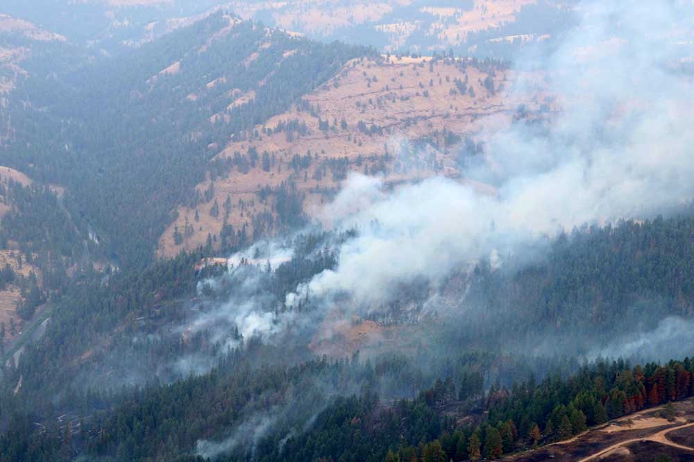
- A view from above of the Battle Mountain Complex FIre on July 27, 2024.
UKIAH — Firefighters assigned to the Battle Mountain Complex continue to push forward on progress across both zones of the incident, fire managers reported on Saturday, JUly 27.
Trending
As of Saturday morning, Oregon State Fire Marshal Green Team is unified with the Oregon Department of Forestry in the protection of structures across the incident as ODF Teams 1 and 3 work in cooperation on the fire line.
Resources from both agencies continue to arrive, and as of Saturday, 1,628 personnel are staffed by the ODF Teams and 12 structural task forces were brought in by OSFM.
The size of the complex is estimated at 159,454 acres, including the Monkey Creek and North Fork Owens fires.
Trending
Fire behavior on the southwestern side of Zone I, near Cupper Creek Road, was active overnight and firefighters focused much of their attention in these areas, protecting structures and building line where possible. Saturday, these efforts will continue, as this remains the most critical and challenging portion of Zone I. Additional resources will be assigned here Saturday with the goal of holding existing line and constructing more where possible. To the west, windy conditions overnight challenged firefighters around the Ant Hill area, and firefighters on this portion of the fire will continue to build and strengthen line.
To the south on Zone I, containment line was further secured around the town of Monument, which has been a focus for firefighters over the past couple of days. Firefighters spent the early morning hours conducting strategic firing operations in the cooler temperatures, which will help to create a stronger and more secure barrier between the fire and scattered homes in the area.
In Zone II, the eastern half of the complex, firefighters made more progress securing and connecting key lines and even beginning mop up in less-active portions of the fire.
Along the north of the fire, crews established and connected lines from Potamus Creek to Highway 395. Along Highway 395, firefighters continued to remove standing, dead timber and began mop-up operations to remove burning materials close to the line to ensure they don’t flare up when temperatures rise in the coming weeks.
Along the southeast, crews conducted firing operations to remove unburnt vegetation. Structural resources, under the command of the OSFM, continued protecting and mopping up around structures.
Evacuations: Level 1 (Be Ready), Level 2 (Be Set) and Level 3 (Go Now) evacuations are in effect. For updated information, visit:
For Umatilla County, follow www.facebook.com/UmatillaCountySheriff or sign up for Umatilla County Emergency Alert System at https://member.everbridge.net/index/2590041373147145.
For Grant County, visit the RAPTOR arcgis site or sign up for alerts at: https://member.everbridge.net/index/825462649520134.
For Morrow County, visit https://experience.arcgis.com/experience/de78333b0d2544f7a320142174aa20ae
Public Land Closures:
The Bureau of Land Management has closed public lands along the John Day River from Kimberly to Dale, and from Kimberly to Service Creek. More information here: https://www.blm.gov/programs/public-safety-and-fire/fire-and-aviation/regional-info/oregon-washington/fire-restrictions.
The Umatilla National Forest has implemented a closure for public lands within the Heppner Ranger District and the North Fork John Day Ranger District. More information at: https://www.fs.usda.gov/detail/umatilla/news-events/?cid=FSEPRD1194462 and https://www.fs.usda.gov/detail/umatilla/alerts-notices/?cid=stelprdb5286768.
Total Estimated Complex Size: 159,454 acres
Monkey Creek Fire: 154,970
North Fork Owens: 4,484 acres
Total Containment: 7%
Cause: Under Investigation
Estimated Cost: $13,700,000
Hand Crews: 47
Engines: 96
Water Tenders: 41
Dozers: 20
Helicopters: 8
Total Personnel: 1,628
Marketplace


-
eEdition

-

-
