Growth slows on Falls Fire, related blazes in Grant and Harney counties
Published 2:16 pm Sunday, July 28, 2024
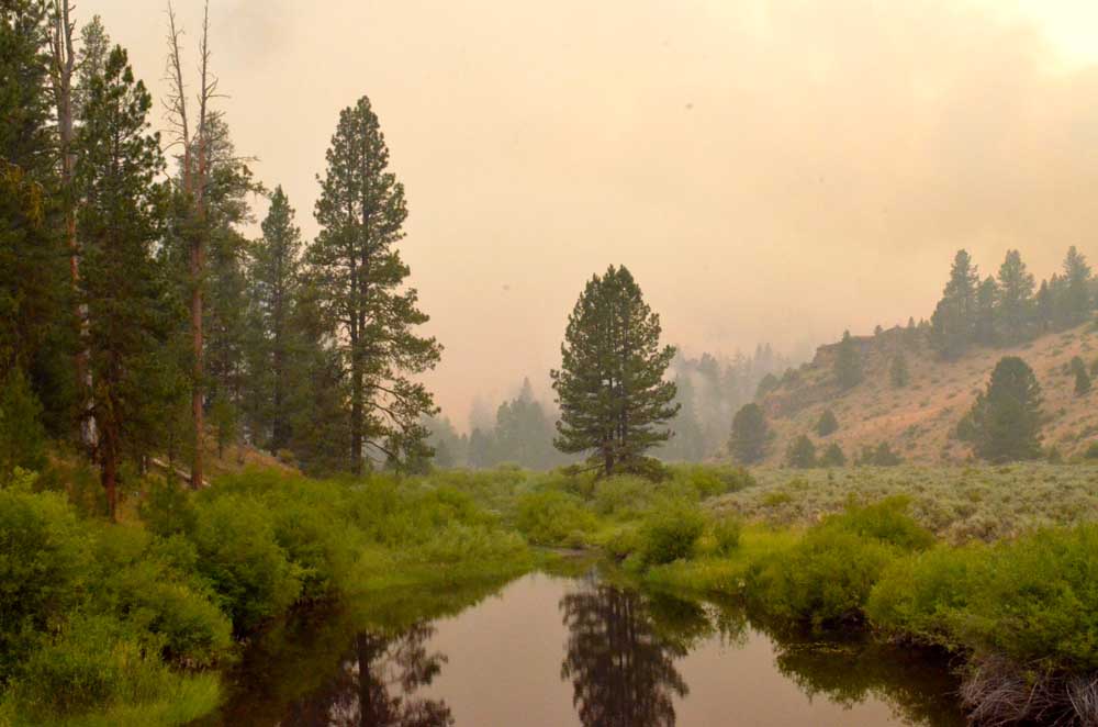
- Smoke from the Falls Fire casts an eerie haze over the Silvies River near the southern edge of Grant County on July 16, 2024.
BURNS — Growth slowed on the Falls Fire and related blazes burning in Harney and Grant counties, fire managers reported on Sunday, July 28.
Trending
Overall, acreage gains on all fires Satrday were much more moderate than in the prior few days, fire officials said.
The Falls Fire stood at an estimated 142,307 on Sunday with 57% containment.
The Telephone Fire was 22,429 acres with zero containment.
Trending
A total of 1,545 personnel were assigned to those two fires and several smaller blazes in the area.
A pair of community meetings were scheduled to provide updates on the Fall, Telephone and associated wildfires. Meetings were scheduled for:
• Sunday, July 28, at 3 p.m. at the Seneca City Hall.
• Monday, July 29, at 7 p.m. at the Chamber of Commerce in Burns.
Falls Fire: On Saturday, there was minimal fire activity on the fire and the southern portion reported no growth.
To the west, crews utilized roads to prep for containment line around the Whiskey Fire and conducted small firing operations to secure the road system contingency lines. Westerly winds were beneficial to the Whiskey Fire for tactical firing operations, pushing the fire back into the Falls Fire burned area. Portions of handline were being tied into the fire perimeter on Whiskey Mountain. The northwest corner of the fire remained quiet and winds were in the favor of firefighters working direct on the fire’s edge. Wildland resources on the northeast portion of the fire, in the Myrtle Creek area, continued to face challenging conditions due to terrain. The remainder of the fire experienced minimal fire activity. Today, crews will continue to monitor and patrol on the south end of the fire and repurpose some resources to other more active areas. To the west, work will progress fire near Whiskey Mountain as conditions allow. Crews are using hoselays along dozer lines to connect the Falls Fire to the Sand Fire.
Sand Fire: On the northern edge of Falls, crews took advantage of favorable winds at the Sand Fire and conducted firing operations to secure fireline. Firing operations remove unburned pockets of vegetation between unburned areas and constructed firelines. The fire is currently near the 3160 road. Turning the corner on the west side of the fire, dozers are being used and firefighters are going as direct as possible. Crews are also using existing road systems to develop containment lines.
Parasol and Poison Fires: Poison and Parasol experienced moderate fire behavior. Crews scouted for indirect attack opportunities. While the Parasol Fire experienced small growth on Saturday, crews were able to secure and improve line all the way around the fire. The fire sits at 485 acres as of Sunday. Yesterday, crews continued to complete line around the Poison Fire and set-up pumps and hoselays. This fire is in tricky terrain which is slowing suppression progress.
Telephone Fire: On Saturday, Telephone Fire remained a top priority area and weather conditions continued to be challenging. Wind-driven fire continued to run, torch and spot in the east and southeast portion of the fire area, near Rattlesnake Rd. Crews encountered strong winds as they worked to engage a new spot fire off the eastern edge of Telephone near FSR 711. Additional crews and air resources responded. The incident utilized 8 hand crews, 10 engines and 6 dozers. OSFM resources provided structural protection. On the fire’s west side, crews have strong containment from the northern portion of the 28 road to the southern part of the fire at the 28 road near Cow Creek. Firing operations will continue in order to remove burnable vegetation on the fire’s edge, between the active fire and the direct fireline. The fire will remain a priority as crews work direct to get a foothold and increase containment. Today, crews are working to secure a slopover across the 28 road and extending indirect line and using road systems, dozer line, existing fuel treatment areas and previous burn areas as well as air support to connect to the Upper Pine Fire area, being mindful of cultural resources in the area.
Ritter Fire: Yesterday, the Alaska Incident Management Team assumed command of the Ritter Fire, located approximately 30 miles east of Burns (just east of the Stinking Water access road) and west of Warm Springs Dam.
Two hotshot crews, elite firefighters that excel in challenging terrain, worked on the southeast corner to establish containment line in advance of expected winds. This part of the fire area remains difficult to access due to steep ravines, channeled winds and rugged topography. Today’s plan is to secure line already created in the southeast corner of the fire and work on a green island of unburned vegetation of potential concern.
With the significant number of new fire starts in the area at this time, firefighters remain vigilant and focused on initial attack (IA) and remain ready to respond to any new threats.
Saturday morning, Oregon State Fire Marshal (OSFM) resources are demobilizing from the Falls and Telephone Fires. OSFM crews have completed structural triage, surface prep, full prep and point protection on structures throughout the incident area. These efforts, in conjunction with the progress made by wildland resources, have helped mitigate the risk to structures.
Wildland resources will be assuming responsibility for ongoing structural protection, and local resources remain available to assist if needed. OSFM resources are available to return if there is an imminent threat to structures that exceeds the capabilities of existing resources.
OSFM would like to extend appreciation to the local communities and agencies for their ongoing support and cooperation throughout this challenging time.
Weather: Smoky conditions will persist Sunday and may worsen throughout the day. A deep inversion layer will take time to lift. Additional smoke from other fires burning throughout the west will impact the area. Temperatures started out much cooler Sunday morning in the fire area and will climb to the mid-80’s by afternoon. Diurnal northwesterly winds will transition to the west, with potential wind gusts between 20-25 mph again Sunday. A potential dry cold front is possible on Monday night.
Evacuations: Evacuations remain in place in both Grant and Harney Counties and have expanded due to the Telephone, Parasol and Poison Fires. For the most accurate evacuation information, please visit the Harney County Sheriff’s evacuation map here: https://tinyurl.com/3zst4sjy, or the Grant County Emergency Management Facebook page at: https://www.facebook.com/profile.php?id=100068819321423.
Closures: Due to active wildfires compounded by extremely unfavorable weather conditions, limited firefighting resources and County Resources, Malheur National Forest officials have temporarily closed lands within the Malheur National Forest.
Investigation: U.S. Forest Service fire investigators are seeking the public’s assistance with any tips or information pertinent to the start of the Falls Fire on the Malheur National Forest. Please submit any information that could assist fire investigation efforts to SM.FS.R6TipHotLine@usda.gov.
Facebook: https://www.facebook.com/p/Falls-Fire-2024-61562126623985/
Falls Fire InciWeb: https://inciweb.wildfire.gov/incident-information/ormaf-falls-fire
Telephone Fire InciWeb: https://inciweb.wildfire.gov/incident-information/ormaf-telephone-fire
Fire Information Line: 541-208-4370, staffed 8 a.m. to 8 p.m.
Email: 2024.Falls@firenet.gov
Harney County non-emergency evacuation questions: 541-589-5579
Air quality questions: 541-573-2271
Smoke Outlooks: https://outlooks.airfire.org/outlook
Size: 142,307
Start Date: July 10, 2024
Location: 13 Miles NW of Burns, OR
Containment: 57%
Total Personnel: 1,545
Cause: Human-caused, under investigation
Structures Triaged: Residences: 386; Commercial: 119 Outbuildings: 760
Resources Assigned: 43 hand crews, 74 engines, 23 bulldozers, 33 water tenders
Aerial resources available to the fire: 2 Type 1 Helicopters assigned
Size: 22,429
Start Date: July 22, 2024
Location: 12 miles NE of Burns, OR
Containment: 0%.
Total Personnel: Staffed by Falls Fire personnel
Cause: Lightning/Natural
Size: 4,204
Start Date: July 25, 2024
Location: 17 miles SW of Seneca, OR
Containment: 0%
Total Personnel: Staffed by Falls Fire personnel
Cause: Undetermined
Whiskey Mountain: 3,402 acres
Cow Creek: 86 acres
Parasol: 485 acres
Poison: 182
Marketplace


-
eEdition

-

-
