Battle Mountain fire crews mop up hot spots; fire at 173,000 acres
Published 11:30 am Wednesday, July 31, 2024
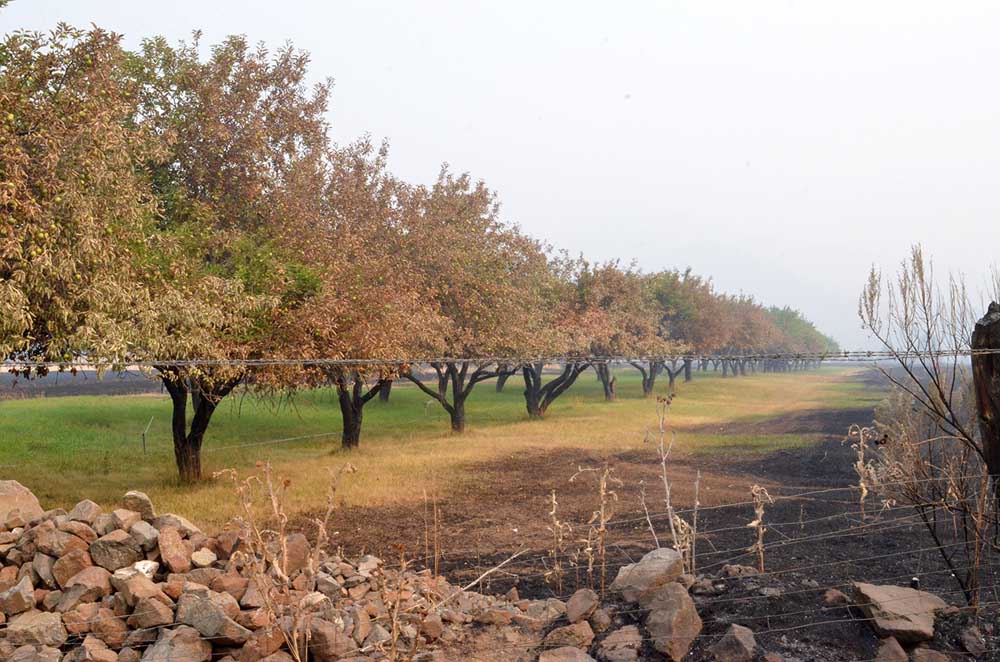
- A strip of fruit trees still stands between two burned-over fields along Highway 402 between Kimberly and Monument on July 28, 2024.
UKIAH — Crews combatting the Battle Mountain Complex wildfire focused on mopping up hot spots in advance of a return to hot, dry weather this week, fire managers stated in their morning update on Wednesday, July 31.
Trending
The size of the complex burning in parts of Grant, Umatilla and Morrow counties was estimated at over 173,000 acres with 14% containment and just over 2,000 firefighters battling the blaze.
Firefighters completed another night of good work on the Battle Mountain Complex, with progress on mop-up operations across both Zones I and II, fire officials said. Temperatures are predicted to begin heating up today, potentially reaching 90 once again, and into the 100s tomorrow. With this increase back into hotter weather patterns, a methodical mop-up process is extremely important to ensure the fire doesn’t flare up and cross firelines.
In Zone I, the focus will continue to be on the southwest corner near Cupper Creek and Top roads, where just north of those locations, an unburned pocket of land remains within the fire footprint. Overhead personnel and firefighters are exploring options on how to address this land, located inside the interior of the fire line. If left as is, it may pose a risk of the fire reigniting in hot conditions when firefighters aren’t present to easily access and address it. Strategic firing operations may occur this morning if conditions allow, which may generate more smoke, however additional hand and bulldozer line are also being put in today as well. On the rest of Zone I, heavy mop up continues, which will help to ultimately increase containment across the incident.
Trending
Continued progress, increased containment and less active fire conditions have decreased the fire threat to structures. As a result, the Oregon State Fire Mashal began releasing Task Forces to their home agencies to rest and restore for the next response. Wildland firefighters and remaining structural resources will continue to work and monitor fire activity around homes and other structures.
Work within the Potamus drainage continues to be the focus in Zone I. Firefighters continue to construct hand and dozer line directly on the fire’s edge within the canyon to stop the fire’s forward progress before temperatures begin to rise tomorrow. As firefighters mop-up and build containment, crews will continue to patrol firelines to locate and extinguish any fire activity along and outside the perimeter. Residents can expect to see smoke within the interior.
As a reminder, the incident is only releasing one morning update each day. You can find more information and mid-day updates on the incident Facebook: www.facebook.com/battlemountaincomplex2024/
Evacuations: Learn more about current evacuation levels for each county at:
For Umatilla County, follow www.facebook.com/UmatillaCountySheriff or sign up for Umatilla County Emergency Alert System at https://member.everbridge.net/index/2590041373147145.
For Grant County, visit the RAPTOR arcgis site or sign up for alerts at: https://member.everbridge.net/index/825462649520134.
For Morrow County, visit https://experience.arcgis.com/experience/de78333b0d2544f7a320142174aa20ae
Public Land Closures: The Bureau of Land Management has closed public lands along the John Day River from Kimberly to Dale, and from Kimberly to Service Creek. More information here: https://www.blm.gov/programs/public-safety-and-fire/fire-and-aviation/regional-info/oregon-washington/fire-restrictions.
The Umatilla National Forest has implemented a closure for public lands within the Heppner Ranger District and the North Fork John Day Ranger District. More information at: https://www.fs.usda.gov/detail/umatilla/news-events/?cid=FSEPRD1194462 and https://www.fs.usda.gov/detail/umatilla/alerts-notices/?cid=stelprdb5286768.
Total Estimated Complex Size: 178,171 acres
Monkey Creek Fire: 173,687
North Fork Owens: 4,484 acres
Total Containment 14%
Cause: Under Investigation
Estimated Cost: $29,200,000
Hand Crews: 67
Engines: 85
Water Tenders: 37
Dozers: 29
Helicopters: 4
Total Personnel: 2,010
Marketplace


-
eEdition

-

-
