Crews brace for hot, dry weather on Telephone, Falls fires
Published 11:02 am Wednesday, July 31, 2024
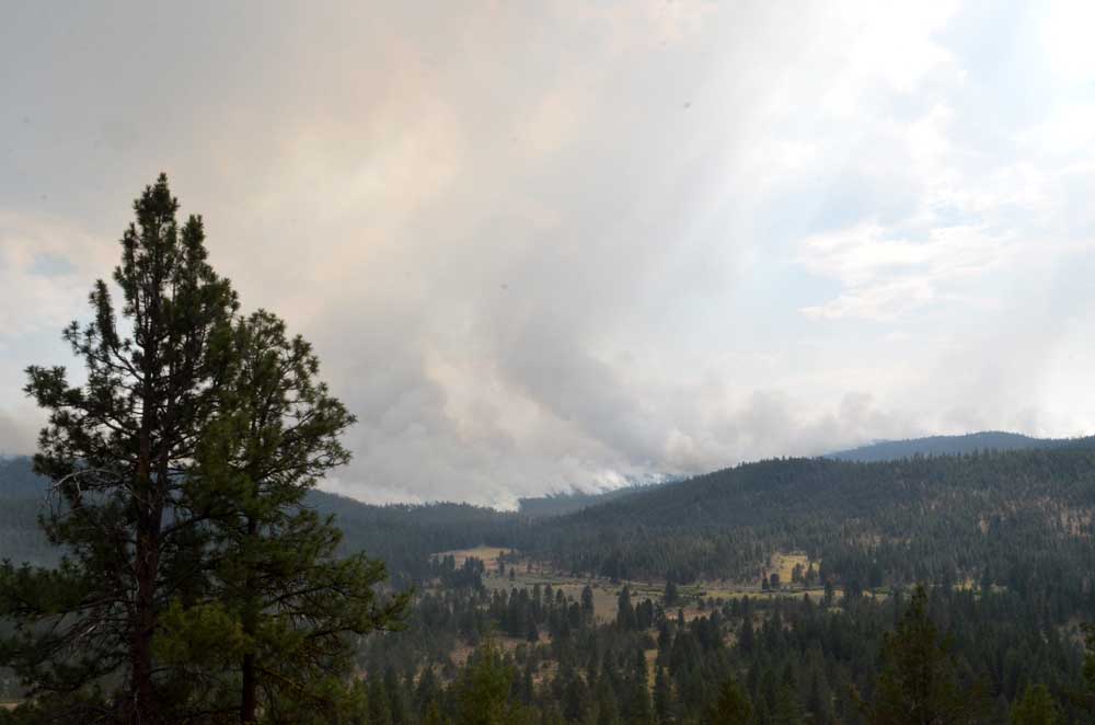
- On July 16, 2024, the Falls Fire had not yet spread into Grant County.
BURNS — After a few days of relatively cool, most weather, crews battling the fires in southern Grant and northern Harney counties are bracing for the return of hot, dry conditions that can lead to flare-ups, fire managers announced in their daily update for the Telephone and Falls fires on Wednesday, July 31.
Trending
The Telephone Fire stood at nearly 37,000 acres with 15% containment, while the Falls Fire was at 142,000 acres and 69% containment. A number of smaller fires continued to burn in the vicinity.
A community meeting is scheduled for 3 p.m. on Wednesday at the Izee Schoolhouse, 45477 Izee-Paulina Highway, Izee.
Leaders of the Alaska Incident Management Team will provide an update on the Telephone Fire, Falls Fire and several other fires they are working to suppress in the area. The meeting will also be shared on the Malheur National Forest Facebook page, as well as the Falls and Telephone Fires Facebook page.
Trending
Fire managers listed the following priorities for Wednesday:
In all areas, crews will continue to improve lines over the next 48 hours to increase their chances of holding through the next weather event.
• Initial Attack: The potential for new fire starts in the area remains significant at this time, and firefighters remain vigilant and focused on initial attack (IA) and are ready to respond to any new threats.
• Along the east side of Telephone Fire, crews will work towards anchoring off of the 2850 road, prepping for small-scale ignition along the road system and dozer line, and working toward the southwest.
• On the southwest side of Telephone Fire, crews will continue to hold and improve existing line.
• Poison Fire: Crews will conduct small-scale firing operations on the northeast corner, working in both directions to continue containment.
Fire Summaries
Many areas are in mop up/hold/improve status, including the Whiskey Mountain Fire area, the northwest sides of the Sand/Falls fires, and east sides of the Falls, Parasol, and Ritter fires. This is due to crews’ great progress in securing good line which continues to hold in these areas, fire officials said.
Mop up is a rigorous process used by wildland firefighters to extinguish or remove burning materials near a fire’s control lines after it has been contained. The goal of mop up is to make the fire safer, reduce smoke, and prevent spread to unburned areas.
Telephone Fire: On Tuesday, crews began work on ignition operations to prevent any northern progression. Local partners from the BLM and the Rangeland Fire Protection Association (RFPA) assisted in creating line to the south and east of the Upper Pine Fire footprint and are also bringing line down to the 2850 road with dozer lines, prepping for small-scale ignition, to corral the fire in a catcher’s mitt shaped area. This work will continue Wednesday. Some of the acreage increase shown for this fire from yesterday is due to firing operations, which are burning fuels during favorable conditions to keep the fire in the desired area. Crews worked in the Poujade Field area using skidgines, which are a cross between skidders and engines containing large water tanks. This equipment can work in steep or loose terrain that engines and water tenders would not be able to access. The west side of the fire is looking good.
On the north side, there was lots of active fire on Tuesday. A shortage of resources requires managers to pick the most effective operations that can hold. We are flexible with the resources we have, pivoting when needed to send them to the most critical areas. Crews are working 24/7 towards reaching priorities on the Telephone Fire, including more than 290 people working the night shift on the fire. Night shift firefighters work in the highest priority areas and places with imminent effects and concerns, and two interagency hotshot crews, highly specialized firefighters, were added to the Telephone Fire overnight Tuesday.
Falls Fire: The south end of the continues to look good and is patrol and monitor status. The Coral Springs area is holding some heat, but is doing okay. On Tuesday, crews had success in firing operations on the nearby Whiskey Mountain Fire, and the fire is staying within containment line. A contingency line behind existing line is being constructed. The north portion of the fire in the direction of Izee has not moved in the last 2 days. Wednesday, crews will continue mop up in the Whiskey Mountain Fire area, and continue progress on a fuel break along the 31 road.
Sand Mountain Fire: Crews worked Tuesday on holding line around Smokey Creek on the northwest side of the fire; work also continued to tie line into the 31 road. The intent is to secure line to protect community of Izee, bringing dozer line around into 31 road to use as indirect line. This process is going smoothly, and crews making good progress with 2.4 miles completed as of Wednesday morning. Crews will continue to work to secure this line on Wednesday. Along the 3145 road, prep work is complete.
Parasol and Poison Fires: The Parasol is completely surrounded with line which crews are continually reinforcing. On the Poison Fire, crews continued small-scale firing operations to hold the fire where it is along the west and south sides of the fire; they will continue this work on Wednesday and are anticipating completion soon.
Ritter Fire: Line is completed around 100% of the fire; crews continue to grid, mop up interior green islands, and hold line. Gridding is an important process done when line is complete where firefighters search for any small fires that could potentially exist inside line, by systematically traveling over an area on parallel courses or gridlines.
Weather: Seasonably cool temperatures prevailed on Tuesday with some afternoon sunshine. Lingering low level moisture led to moderate afternoon humidity values. On Wednesday there will be a warming and drying trend, with temperatures increasing by 5 to 10 degrees and relative humidity dropping 5-10%. Light winds this morning will give way to typical afternoon westerly winds.
Evacuations: Due to the continued growth east of the Telephone Fire, evacuations have expanded in that area. For the most accurate evacuation information, please visit the Harney County Sheriff’s evacuation map here: https://tinyurl.com/3zst4sjy, or the Grant County Emergency Management Facebook page at: https://www.facebook.com/profile.php?id=100068819321423.
Closures: Due to active wildfires compounded by extremely unfavorable weather conditions, limited firefighting resources and County Resources, Malheur National Forest officials have temporarily closed lands within the Malheur National Forest.
Investigation: U.S. Forest Service fire investigators are seeking the public’s assistance with any tips or information pertinent to the start of the Falls Fire on the Malheur National Forest. Please submit any information that could assist fire investigation efforts to SM.FS.R6TipHotLine@usda.gov.
Temporary Flight Restriction (TFR): TFRs in the area have been changing; pilots should check the latest information on the Federal Aviation Administration TFR website prior to flying: https://tfr.faa.gov/tfr_map_ims/html/index.html
Facebook: https://www.facebook.com/p/Falls-Fire-2024-61562126623985/
Falls Fire InciWeb: https://inciweb.wildfire.gov/incident-information/ormaf-falls-fire
Telephone Fire InciWeb: https://inciweb.wildfire.gov/incident-information/ormaf-telephone-fire
Fire Information Line: 541-208-4370, staffed 8 a.m. to 8 p.m.
Email: 2024.Falls@firenet.gov
Harney County non-emergency evacuation questions: 541-589-5579
Air quality questions: 541-573-2271. Air quality information, searchable by ZIP code: www.airnow.gov
Smoke Outlooks: https://outlooks.airfire.org/outlook
Size: 36,668
Start Date: July 22, 2024
Location: 12 miles NE of Burns, OR
Containment: 15%.
Total Personnel: 364 personnel
Cause: Lightning/Natural
Resources Assigned: 9 hand crews, 15 engines, 6 bulldozers, 7 water tenders, 3 skidders
*Resource numbers are changing rapidly as crews are re-allocated to this Fire.
Size: 142,307
Start Date: July 10, 2024
Location: 13 Miles NW of Burns, OR
Containment: 69%
Total Personnel: 769
Cause: Human-caused, under investigation
Structures Triaged: Residences: 386; Commercial: 119 Outbuildings: 760
Resources Assigned: 34 hand crews, 44 engines, 16 bulldozers, 24 water tenders, 6 masticators, 8 skidders
Size: 4,927
Start Date: July 25, 2024
Location: 17 miles SW of Seneca, OR
Containment: 0%
Total Personnel: Staffed by Falls Fire personnel
Cause: Lightning/Natural
Size: 459
Start Date: July 23, 2024
Location: Stinking Water Mountain NE of Crane, OR
Containment: 52%.
Total Personnel: 41 personnel
Cause: Lightning/Natural
Resources Assigned: 1 hand crew, 4 engines, 1 water tender
4 Oregon National Guard hand crews will be arriving to assist with the firefighting effort on these fires (2 crews arrive on July 31st and 2 arrive on August 1st.
Aerial resources available: 3 Type 1 helicopters assigned and available to all fires in the area. 4 Single Engine Airtankers (SEATs) available for initial attack. To date, aerial resources have dropped about 1⁄2 million gallons each of water and retardant on these fires. Helicopters drop water and fixed wing planes drop retardant. Air resources can fly 10 flight hours per day. Additional planes come from a pool of resources serving the northwest and go to fires designated with the highest priority in the U.S.
Whiskey Mountain: 4,212 acres
Cow Creek: 86 acres
Parasol: 485 acres
Poison: 593 acres
Total Personnel: Staffed by Falls Fire personnel.
Marketplace


-
eEdition

-

-
