Lone Rock Fire reaches 80% containment
Published 9:22 am Wednesday, July 31, 2024
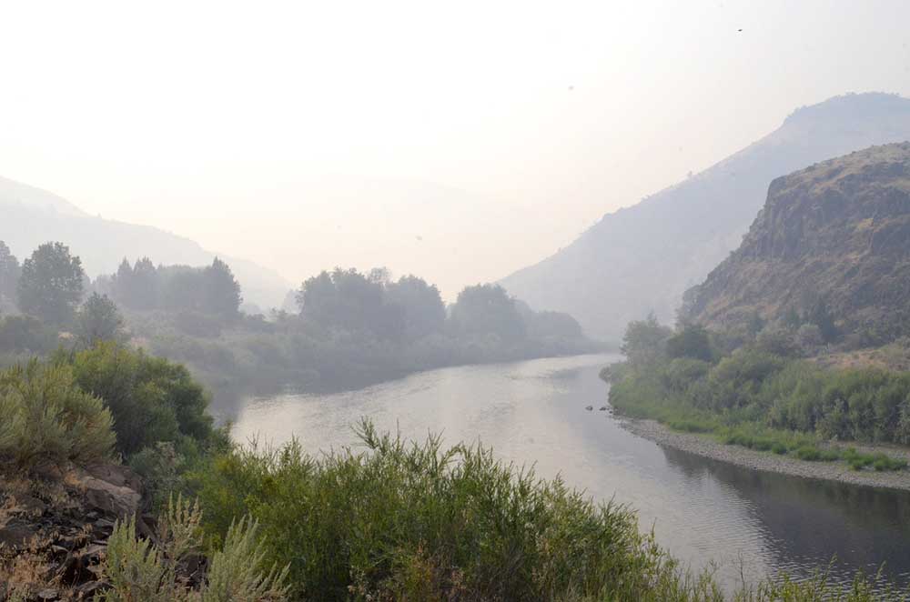
- Smoke from the Lone Rock Fire fills the canyon of the John Day River west of Kimberly on July 28, 2024.
LONEROCK — Fire crews continued mop-up operations on the Lone Rock Fire, expanding containment to 80% as a new team took command of the response, fire managers reported in their morning update on Wednesday, July 31.
Trending
Burning from Lonerock south to Spray, the fire stands at a little over 137,000 acres and has reached 80% contianment.
The Southwest Area Complex Incident Management Team 2 (Team2), led by Incident Commander John Truett, assumed command of the fire at 6 o’clock Wednesday morning. Incident objectives include firefighter and public safety, protecting property, infrastructure, and other values at risk while implementing full-suppression tactics.
On Tuesday, crews continued work mopping up areas retaining heat on the east and west sides of the fire, fire officials said. On the east side, work was completed on the area between Flatiron Spring and FSR 25, and an additional 3% of containment was added to the map, bringing the total containment to 80%.
Trending
Firefighters remained heavily engaged on the west side of fire working on the slopover fire near Notch RD. Chipping work was completed along HWY 19. The north and south ends of the fire remain in patrol status, with no areas of concern observed.
On Wednesday, the operational objectives will remain largely the same as they have been over the last several shifts. Crews will continue to mop-up and secure the lines on the east and west sides of the fire perimeter and continue to patrol the remainder of the fire area.
Weather: A ridge of high pressure over the Four Corners region will begin to re-amplify into the Northwest region on Wednesday. Temperatures will warm to near average with highs in the 80s to low 90s. Relative humidity will be on a downward trend bottoming out in the 20s. Winds will remain light, and terrain driven.
Evacuations: There are no Level 3 evacuations in place for the Lone Rock Fire.
For Gilliam County evacuation information, visit Gilliam County Sheriff’s Office Facebook page.
For Wheeler County evacuation information, visit Wheeler County Sheriff’s Office Facebook page.
For Morrow County evacuation information, visit Morrow County Sheriff’s Office Facebook page.
Closures:
For updated road closure information, visit https://www.tripcheck.com/.
Umatilla National Forest Order Number 06-14-02-24-02 includes prohibitions within the Heppner Ranger District on the Umatilla National Forest.
Bureau of Land Management (BLM) Prineville District Office issued an Emergency Public Land Closure on BLM-managed lands along the main stem John Day River and along the North Fork John Day River from Kimberly, Ore. to Dale, Ore.
Fire Information: 541-208-4369 from 8 A.M. to 8 P.M. – 2024.0404rvlonerock@firenet.gov
InciWeb: https://inciweb.wildfire.gov/inciden…/orprd-lone-rock-fire
Facebook: https://www.facebook.com/LoneRockFireInformation
Size: 137,221 acres
Start Date: July 13, 2024
Cause: Under Investigation
Fuels: Timber, Understory, Grass
Containment: 80%
Resources: 447
Marketplace


-
eEdition

-

-
