Shooting the Breeze: Feral Joe’s hunting map
Published 7:00 am Saturday, February 22, 2025
- Some maps are better than others.
It was 2005, and I had just gotten my first Nokia cell phone for my 21st birthday. I was living in a rental in Powell Butte, Oregon, and if you stood in the right place you might get through a single phone call without being dropped. My roommate was a family acquaintance who fancied himself a real ladies’ man. As I came to know, Feral Joe Jenkins owed everyone in town, in cash or favors.
Trending
Luckily, my best friend, Andy, who had also recently turned 21, lived close enough by that we got to go hunting quite a bit. The back pasture was full of jackrabbits just before dusk, and to be safe we only shot with .22 shorts at targets inside of 40 yards. That fall, Andy and I bought black bear tags in hopes that we would get lucky.
Andy really wanted to shoot one with his Lyman Great Plains .54-caliber muzzleloader, so we practiced with it a lot at the range, deciding that 100 yards was about the farthest we should shoot. I was to be backup with my .300 Winchester Magnum if anything went wrong. We hunted all over; in the hills west of Bend, in the national forest above Mitchell, and several places in between. We saw antelope, deer, elk, coyotes — everything but black bear.
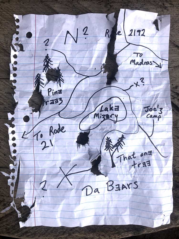
Feral Joe, my roommate, was a bowhunter and, hearing about our plight, he suggested we go up to Mount Hood. Up there he had seen all kinds of bears and figured we could easily fill both of our tags. Neither of us had spent any time “up there,” so describing landmarks or numbered forest roads was futile. Just then Feral Joe had a light bulb moment: He would just draw us a map! As he put pen to paper, Andy and I talked logistics. Grab dinner and our gear after work Friday, spend the night, hunt all weekend! What could go wrong? We practically had bear meat in the freezer.
Trending
Things went pretty much as planned until we got to the mountain. We pulled off the side of the forest road and, as it was pouring rain, we decided to just sleep in Andy’s Jeep. I don’t think either of us rested very well that night. It was bitter cold in spite of our sleeping bags, and my sleep apnea (undiagnosed at that time) made me snore like two grizzlies running a sawmill.
For most of the next day we drove around, feverishly trying to make sense of Feral Joe’s map. The curvy lines and nameless roads had us both confused. Occasionally we would stop and glass. A few times we thought we saw bears, but each time it was only a charred stump. Seeing some bear sign was encouraging so we tried a few predator call sets, to no avail. After we had made what seemed to be our 15th circle, backtracking, I crumpled the map and contemptuously tossed it into the floorboard. Andy laughed and said, “Stupid map!”
Deciding it just wasn’t our year for black bear, we pulled into a gravel pit and ate a late lunch. After lunch Andy turned his baseball cap around backwards and smirkingly walked Feral Joe’s map downrange. Retrieving his Ruger .30-06 from the Jeep, he cycled the action and took aim over the hood. Four shots later, Feral Joe’s map had four bullet holes in it, dead center.
Thank goodness we have smartphones and applications like OnX these days. Showing someone where to go and how to get there has never been easier. But if you have to resort to a hand-drawn map for giving directions to a hunting spot, please make it legible or don’t be surprised if it comes back riddled with bullet holes.
Write to us at shootingthebreezebme@gmail.com today!
Marketplace


-
eEdition

-

-
