Telephone, Falls fires grow overnight, fueled by hot weather
Published 1:19 pm Saturday, August 3, 2024
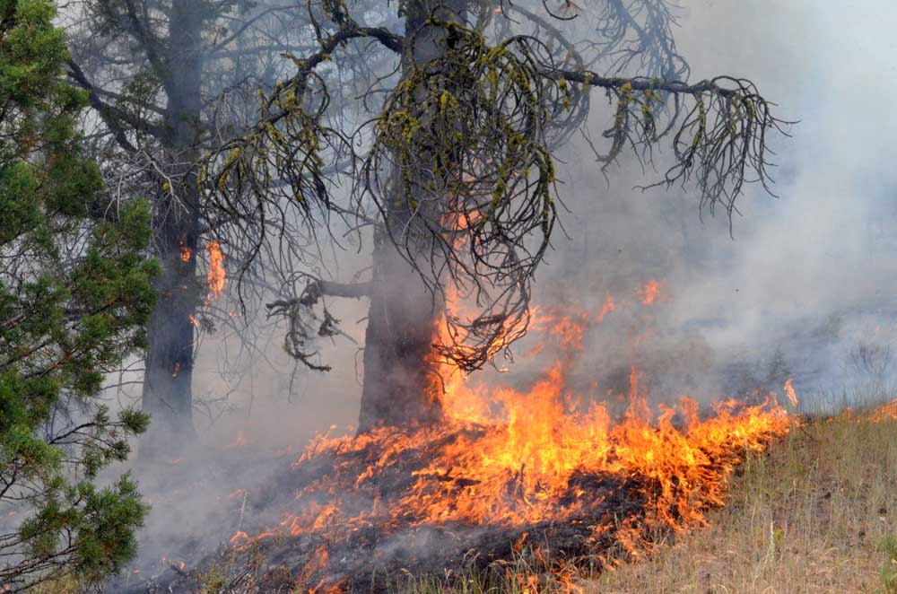
- Flames climb a hill July 16, 2024, as the Falls Fire spreads in Grant County. (Blue Mountain Eagle, File)
BURNS — Both the Telepone and Falls fires grew overnight as crews battled difficult weather conditions, fire managers reported in a daily update on Saturday, Aug. 3.
Trending
The Telephone Fire now stands at over 50,000 acres with 23% containment. The Falls Fire is at an estimated 146,000 acres and 73% containment.
The two wildfires are the largest of a cluster of blazes burning in southern Grant and northern Harney counties.
A community meeting will be held on at 3 pm, at the Drewsey School Gymnasium, 7882 Drewsey Road, Drewsey.
Trending
Leaders of the Alaska Incident Management Team will provide an update on the Telephone Fire, Falls Fire and several other fires we are working to suppress in the area. The meeting will also be shared on the Malheur National Forest Facebook page, as well as the Falls and Telephone Fires Facebook page.
The National Weather Service has issued a Red Flag Warning (in effect through 11 p.m.) Saturday in the fire area.
Aerial resources include two Type 1 helicopters and one Type 1 Uncrewed Aircraft System (UAS) assigned and available to all fires in the area. Air support also includes a lend/leasing system and additional aircraft will be pulled from different areas of the region to the fires Saturday.
Fire managers noted that weather and fuel conditions are in alignment for extreme fire behavior and set the following prioritiesfor Saturday:
1) Initial Attack: The potential for new fire starts in the area remains significant at this time, and firefighters remain vigilant and focused on initial attack (IA) and are ready to respond to any new threats.
2) Protect and prepare homes along the north and northwest portion of the Telephone Fire. Support wildland firing operations and line control along the north and northeast flank of the Telephone Fire.
3) Work to hold line and prevent spread toward King Mountain on the southwest side of the Telephone Fire.
4) Continue piecing together line along the northwest corner of the Falls Fire; look for contingency lines to prevent spread to the west.
5) Hold and improve existing line on the east and northeast sides of the Telephone Fire, and work to tie in the burned area along the upper side of the northeast corner of the east side.
Critical fire weather conditions continue today, and fire plumes could be visible over parts of the fire areas.
Fire summaries
Telephone Fire: The Telephone Fire grew by 4,500 acres overnight, mainly in the northwest corner and the interior of the northeast corner, within existing line. Small-scale ignition operations that crews have done to bring line towards the Upper Pine Fire footprint have made it possible to establish an anchor multiple times for this incident, which has been a huge success.
With no more burnable vegetation, Upper Pine created an anchor point for crews. Anchor points are a safe place to put resources to add line, then small-scale ignition operations can be done off these areas to remove additional fuel.
Friday, on the northeast side of the fire, crews completed a small-scale ignition operation of a piece of unburned vegetation between the Upper Pine area and another burnout. Crews will continue using the same tactics Saturday if conditions allow.
Crews on the east side will do the same, working towards the northeast. Some of the recent intense weather has helped with these operations, and crews have gained 3/4 of a mile of depth into the containment area.
Crews worked the southwest corner of the fire on Friday to address a slopover, with help from air support. A new small slopover on the southern portion of the 2820 occurred Friday evening and crews are actively working to prevent its spread. They will continue this on Saturday with assistance from additional crews.
A task force will monitor the southwest and the east sides of the Telephone Fire. Friday, structural task forces, each consisting of five fire apparatus and approximately 15 firefighters, worked along the northwest corner of the fire.
Fire crews made it up to King Mountain where they prepped and wrapped communication equipment with fire resistant materials. The communications equipment is a critical resource to emergency services operations in the region. The structural task force assigned to night shift worked along the northwest corner of the fire. Firefighters spent the evening prepping homes along Purdy Road and working near the 2820 Road.
Saturday, crews will continue to hold, improve, and mop up existing line on the east and northeast sides of the Telephone Fire, and work to tie in the burned area along the upper side of the northeast corner of the eastern perimeter, working towards achieving 100% containment in this area.
Falls Fire: The Falls Fire grew by 1,400 acres. Growth for both the Falls and Sand fires was sandwiched between the two fires, in the vicinity of the southeast side of the Sand Fire. The Falls and Sand fires are now merged.
The south end of the Falls Fire, as well as Whiskey Mountain on the northwest side and the east side, south of Myrtle Creek continue to look good; line in these areas withstood Friday’s weather. On the northeast side of the fire, north of Myrtle Creek, crews continue making good progress on a fuel break.
Where there are areas of open fireline along the northeast side of the fire, crews are strategically adding indirect line that can be monitored and patrolled, including a shaded fuel break along the 31 road, which is nearly complete. A shaded fuel break is when a majority of, but not all, trees are removed, with 75-foot separation between trees, and surface fuels are removed to the extent possible.
These breaks are still aesthetically pleasing but have enough separation that fire won’t spread crown to crown. On the south and west end of Whisky Mountain, crews continue to make progress gaining depth into the containment area.
Saturday, crews will monitor the northwest corner of the Falls Fire, continuing work to piece together line along Gilbert Ridge. They will use direct tactics on the north side of the fire and look for contingency lines to prevent spread to the west. On the east side, south of Myrtle Creek, crews will work to hold the line where there was a recent slopover. This area is currently looking good, and crews from the Poison Fire will arrive to assist.
Sand Mountain Fire: The Sand Fire is now merged with the Falls Fire. Friday, two hotshot crews and air resources worked on a recent slopover across dozer line near Gilbert Ridge and made good progress. Night shift crews put in indirect line along the southwest side of where Sand and Falls meet. Some small-scale ignition operations were done along the 3160 road on the south side of the fire.
In the upper green pocket of unburned vegetation around the Falls and Sand fires, line has been holding to limit northwest spread and limit western progression. On Saturday, additional resources from the Telephone Fire will assist with efforts on the north side of Sand.
Parasol and Poison Fires: There was no movement on either the Poison or Parasol Fire despite Friday’s weather.
Crews are continuing to clean up pockets of fuel to more deeply secure the control line. In some areas of the containment along the Poison Fire, crews have begun cold trailing, feeling with the back of one’s hand along the ground near the fireline to make sure no heat remains.
Ritter Fire: Friday, the fire was checked; line had held, despite extreme weather. One area of smoke was found and addressed. Engine crews will continue to monitor on Saturday.
Weather: A Red Flag Warning is in effect for Saturday. There is a potential for dry thunderstorms across the planning area today, with potential for dry lightning. Temperatures will be in the 90s with relative humidity in the teens; north and northwesterly winds with gusts of up to 25 mph.
Evacuations: The Telephone Fire is pushing toward King Mountain and notifications have been made to the Trout Creek area, which remains in a LEVEL 3 evacuation zone.
For the most accurate evacuation information, please visit the Harney County Sheriff’s evacuation map here: https://tinyurl.com/3zst4sjy, or the Grant County Emergency Management Facebook page: https://www.facebook.com/profile.php?id=100068819321423.
Closures: A closure is in effect for the two portions of the Malheur National Forest that run west of 395B, north of Mt. Vernon and south of Long Creek, in the Fox Valley area, including all roads, trails, and camping locations within the fire closure area. A detailed map of the closure if included and available on the Malheur National Forest website (https://www.fs.usda.gov/malheur/) and offices.
Investigation: U.S. Forest Service fire investigators are seeking the public’s assistance with any tips or informationpertinent to the start of the Falls Fire on the Malheur National Forest. Please submit any information that couldassist fire investigation efforts to SM.FS.R6TipHotLine@usda.gov.
Temporary Flight Restriction (TFR): TFRs in the area have been changing; pilots should check the latest informationon the Federal Aviation Administration TFR website prior to flying: https://tfr.faa.gov/tfr_map_ims/html/index.html
Facebook: https://www.facebook.com/p/Falls-Fire-2024-61562126623985/
Falls Fire InciWeb: https://inciweb.wildfire.gov/incident-information/ormaf-falls-fire
Telephone Fire InciWeb: https://inciweb.wildfire.gov/incident-information/ormaf-telephone-fire
Fire Information Line: 541-208-4370, staffed 8 a.m. to 8 p.m.
Email: 2024.Falls@firenet.gov
Harney County non-emergency evacuation questions: 541-589-5579
Air quality questions: 541-573-2271. Air quality information, searchable by zip code: https://fire.airnow.gov/
Smoke Outlooks: https://outlooks.airfire.org/outlook
Size: 50,863
Start Date: July 22, 2024
Location: 12 miles NE of Burns, OR
Containment: 23%.
Total Personnel: 436 personnel Cause: Lightning/Natural
Resources Assigned: 11 hand crews, 20 engines, 6 bulldozers, 7 water tenders, 4 skidders
Size: 145,735
Start Date: July 10, 2024
Location: 13 Miles NW of Burns, OR
Containment: 73%
Total Personnel: 694
Cause: Human-caused, under investigation
Structures Triaged: Residences: 386; Commercial: 119 Outbuildings: 760
Resources Assigned: 29 hand crews, 44 engines, 14 bulldozers, 24 water tenders, 7 masticators, 8 skidders
Size: 5,805
Start Date: July 25, 2024
Location: 17 miles SW of Seneca, OR
Containment: 0%
Total Personnel: Staffed by Falls Fire personnel
Cause: Lightning/Natural
Size: 461
Start Date: July 23, 2024
Location: Stinking Water Mountain NE of Crane, OR
Containment: 100%.
Total Personnel: 6 personnel
Cause: Lightning/Natural
Whiskey Mountain: 4,345 acres
Cow Creek: 86 acres
Parasol: 485 acres
Poison: 1,042 acres
Total Personnel: Staffed by Falls Fire personnel
Marketplace


-
eEdition

-

-
